WILLIAMS ARIZONA HISTORICAL MAPS: A WALK THROUGH TIME
WILLIAMS ARIZONA HISTORICAL MAPS: A WALK-THROUGH TIME
COPYRIGHT; ALL RIGHTS RESERVED (5/10/22)
(All Maps in this section, unless otherwise noted; Williams, Arizona Sanford Insurance Maps; Library of Congress, Geography and Map Division)
The town of Williams is one of those communities that just seems to grow on a person. It is a great place to visit, spend a few days in the many comfortable and affordable hotels, walk the downtown area, or just take a stroll through the neighborhoods. The variety of architecture is remarkable. There are numerous shops to explore and finding those items you've been looking for. After a day of exploration, there are restaurants to meet the tastes of any hungry visitor. All this, just in the downtown area. Recreation abounds in the nearby region; however, our focus today is on the town's history through time.
Williams is blessed to have a compressed downtown area, easily walked on a nice day. The town buildings are well-documented in the Sanford Insurance Maps, dating from 1892-1943. These detailed, hand-drafted maps were made for insurance purposes, specifically in establishing fire insurance rates. Today, they provide a wealth of information as to the growth and development of the community.
1892


The 1892 maps show the township has been platted and established; streets are laid-out in the grid-like pattern of early townsites. Names and numbers have been assigned; civilization can now begin to take root. Map 1 shows the beginnings of the business district along Railroad Avenue, which parallels the tracks of the Atlantic and Pacific Railroad. The saloons and houses of ill-repute are springing up along the avenue, particularly at Second Street. The Grand Canyon Hotel has been built on the corner of Second and Bill Williams Avenue.
Not to be outdone by the saloons, businesses have begun along both Railroad and Bill Williams Avenues. At first planted in canvas tents, they soon gave way to wooden structures. This would soon draw the menacing glowing figure of fire, which was the nemesis of early towns.
The Methodist Church was established on Sherman Avenue and Second Street, just a block from the school located on Second and Sheridan. Both would see the town grow through the decades; the school building would burn and be rebuilt, then once again be reborn as a new structure. The church building would be like a solid rock, standing firm as a beacon of hope and salvation through whatever may come.

Methodist Church, 2022

Williams School
The building was enlarged in 1906, burned down in 1912.


It was rebuilt and enlarged through the 1930s,
and was expanded with two wings.
The High School was relocated to a new facility that was
built on former Saginaw Mill property.
In 2022, this building is now an apartment complex.
1901


Map 1 Map 2


Map 3 Map 4
The 1901 maps show a marked change in the character of Williams. The business district had grown, and more permanent structures made of stone, brick and mortar were built. This was a result of the fires occurring in 1895; the flaming specter was once again poised to strike. Fires would sweep the town twice again, causing alarming and costly damage. The pictures of a smoldering apocalypse emblazoned the pages of The Williams News. The newspaper did not escape unscathed, as whatever parchment or paper were employed to print the news. Like most of the businesses that were destroyed, they relocated to another site and kept pressing ink to paper, keeping the citizens informed. What can be gleaned from the pages that document those dark days, was the resolve of a once thriving town to restock, replenish, build again and prosper to even greater things than before. This time brick and mortar was to be the building material of choice. Resolute merchants decided to stay the course; normalcy would once again return.
In 1901 the town was legally incorporated. With that came the usual trappings of a new metropolis: a town marshal, a health and fire marshal, and the plethora of new ordinances. These included changes to the way prostitution and gambling would be observed- taxed and regulated, not banished.
This affected the area of Grand Canyon Boulevard, and Second Street, and as can be seen by Map 1, they enjoyed a very profitable and active business dispensing the pleasures of the flesh.
THE RED LIGHT DISTRICT

The town council decided to address the problem of prostitution and gambling by constraining such business to a designated district and profiting from the activities by licensing and taxing the businesses. This was in the area of Railroad Avenue and Second Street. Legalized prostitution became the norm in this district, until 1910 when it was repealed. The problem became worse, and once again it was legalized and regulated until World War One. The War Department, in the name of protecting the morality of the soldiers, in 1918 banned prostitution on a national level.
Along with brothels and prostitution, gambling and saloons were restricted to this area. At this time, some fourteen saloons, often dispensers of other entertainment, existed in Williams. Several notable buildings still exist from this era. One of these establishments was known as the first legally licensed brothel in the State of Arizona. If you get a first place in something, put the trophy on display.
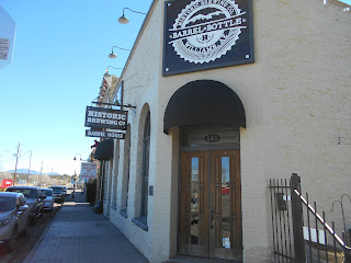
THE CABINET SALOON AND TETZLAFF BUILDINGS

The historic structures are located on the corner Grand Canyon Ave. and Second Street.

The Cabinet Saloon, now known as The Red Garter Historic Inn.
You can stay at the Inn.
The restaurant is Anna's Place, Grand Canyon Cafe.
It is an authentic local place to eat great food.

Plaque reads:
"The Cabinet Saloon
Built 1893
Has been placed on the National Register of Historic Places by the United States Department of the Interior. The Cabinet Saloon was a boisterous spot along "saloon row." Here railroaders, cowboys, loggers, and rowdy local residents came to spend their paychecks in saloons, gambling houses, opium dens, and houses of ill repute. In the last 100 years, various owners altered much of the Cabinet Saloon's unique character. In 1993, the building underwent a major renovation, earning it the 1994 Arizona Main Street Historic Design Award."

"Only slightly haunted." Passersby tell the tale of seeing the specter of a woman clad in red, who's velvet dress and flowing scarf beckon to the weary traveler; her alluring charms drawing another patron into the seductive web she has spun.


The plaque reads:
"Tetzlaff Building
This Victorian -Romanesque style building, designed as a saloon and bordello was built in 1897 by German Tailor August Tetzlaff. Offering female company in eight cribs and an elegant parlor, it also boasted a two-story outhouse. Whisky, pool tables and poker games provided entertainment on the ground floor, as did the Chinese Restaurant and opium den located at the back of the building. This brick building stopped the devastating 1901 and 1903 fires that burned down all of "saloon row" to the east. It is now on the National Register of Historic Places."
THE WILLIAMS DEPOT AND VISITOR CENTER
Diagonally, across the street, is the Williams Visitor Center. This structure, as indicated on the left side of Map 1, was originally located directly across the tracks from Second Street. The building was the original passenger station, built in 1901, on the Atlantic and Pacific, latr Santa Fe Railroad. The City of Williams had petitioned the Santa Fe to place a vehicle crossing on the tracks at Third Street. They countered with the offer of placing it on Second Street, to which the city agreed. This meant that the station had to be moved to its current location in 1904. This also meant that the main north entry to the downtown area directly passed the red-light district.

It became a freight depot after the move. The old depot remained abandoned for some time, until a group of dedicated volunteers restored the depot, becoming the Visitor Center. In addition to being a historic building in its own right, the center offers travel information by a friendly and well-informed staff. A small but well-designed museum provides the visitor with a glimpse into the history of Williams.
THE GRAND CANYON HOTEL
One block south on second Street, at the corner of Bill Williams Avenue, is the Grand Canyon Hotel. This hotel was once the premier place to stay in Williams. 


Built in 1892 by Samuel E. Patton for Cormick E. Boyce known as 'The man who built Williams." With its own water supply, it was the only surviving building of the 1895 fire. First class hotel designed to appeal to travelers to the Grand Canyon. Ground floor had many uses- drug store, grocery store, dance hall, and Knights of Pythias meeting hall."
Cormick E. Boyce, also known as C.E. Boyce, was well known as 'The man who built Williams." He had his hand in just about every building project in Williams. His foresight and dedication helped lay the groundwork for the town we know today.

Side view of the Hotel.

Rear view of the Hotel. Note the covered skylight features on the roof. This allowed sunlight into the center of the building. The tall brick chimney was a possible later addition. The hotel laundry was located in the alleyway. The attached restaurant to the hotel had a separate liquor room.
The hotel's water supply was provided by a well, located in the corner of Grant Avenue and Fourth Street. Water was lifted by a 10 H.P. pump. A water line was laid to the corner of Sherman Avenue and First Street. At this location were two tanks of 30,000-gallon capacity, with the upper tank at an elevation of 52 feet. The hotel was connected to the two tanks. The water supply was built by C.E. Boyce. Today, the two locations are private residences, with the well apparently still in operation.
Diagonally across the street from the hotel, on the northwest corner, resides The Citizens Bank.
THE CITIZENS BANK


The plaque reads thus:
"CITIZENS BANK
This Neo-Classical Revival style building opened with much fanfare on Armistice Day, November 11, 1918. The bank was the financial center of the lumber, ranching and railroad operations in the area until it closed in 1958. The extensive Terra Cotta detail is found only on this building."
The Bank is a beautiful building, built to impress the populace. For a bank, it is a relatively small structure. It now hosts a Jewelry Store, with one of the finest collections of gemstone jewelry in the area.
THE POLSON BROTHERS BUILDING

This handsome, solid building is located on the Northeast corner of Bill Williams Avenue
and Third Street. This edifice is the Polson Brothers Building, built in 1895. It boasts a rough-cut stone first floor, and a red brick second story. All of the doorways and window arches are hand laid stone. A very attractive and intricate example of this type of building construction.
The Map indicates that on the corner was a bank, with a drugstore and general store on the right. Located on the westside was the entrance to the Telephone Office and Exchange. This building was built in response to the mass destruction caused by fires.

The West facade. The center door was the Telephone Office and Exchange.

Close-up of the doorway.

Close up view of the stone construction. The former bank is now home to Open Road Cowboy store. A fine shop specializing in custom, authentic leather western wear. To the west along the avenue is Western Outfitters and De Berge's Saddlery, another fine store that specializes in modern western wear. Both establishments feature on-site workshops, viewable by the customer.
The Williams Electric Light and Power Company was located on the southeast corner of 6th Street and Bill Williams Ave. The plant was built by J.C. Brown, Manager at the Saginaw Mill; and C.E. Boyce, known as the "Builder of Williams." The plant was sold on November 1, 1899, to Prince A. Mellick and John Walsh, renaming it the Grand Canyon Electric Light and Power Company (Fuchs, 129, 130.) The site is now occupied by a parking lot and the town's Dairy Queen. (A more in-depth examination of the trials and travails of providing electricity to the Mill and the City of Williams is addressed in a separate chapter.)
THE WILLIAMS BREWING COMPANY BOTTLING WORKS


(Sanford Maps 1898,1901.) The brewery was owned by Mr. A.M. Conrad.
What western town is not complete without a brewery? This was located just north of the Saginaw and Manistee Planing Mill, on the west-end of town. Little is known about this facility. It is possible that it became one of the legendary dispensers of local beer and relocated to another site north of the Atlantic and Pacific tracks. Towns of this era would have welcomed such an establishment, since there was a great demand for beer in the nearby saloons. The bottling works could also have been used to capture in a bottle other alcoholic spirits, or beverages more suitable for non-alcoholic tastes. The site is now covered by an interchange with Route 66.
THE LOMBARD, GOOD AND COMPANY SMELTER

In the lower left-hand corner of Map 3 is an illustration of The Lombard, Good and Company Smelter. Notation on map reads: "Located 3/4-mile east of RR Depot. Not in operation Oct. 1901. Iron roofs. Whitewashed inside- water to be supplied from R.R. water supply to a tank to be located on a hill south of plant."
The plant was located on a hillside, with the railroad tracks (mainline and spur?) on the southside of the building. This would mean the plant building was facing to the north. The main structure included the bin building and a furnace in the northwest corner. A basement was indicated on the east side. Other machinery is not identified in the structure. To the south of the building, between two tracks, was the crusher, used to pulverize the ore.
The mill was completed June 1898, and the first load of ore was delivered in July. It is questionable if the mill actually processed any ore, other than some test material. The company had an agreement with the Atlantic and Pacific to provide water to the mill, however the pipeline was damaged beyond repair. Rumors of sabotage abounded- whispered about town.
Lombard, Good and Company were involved in the development of the Anita Mines, north of Williams, and south of the Grand Canyon. In order to supply the smelter, a railroad would have to be built. This same company, after acquiring the necessary funding, began building the Santa Fe and Grand Canyon Railway to the South Rim.
The ore proved to be of low grade from the mines, meaning there was a nominal amount of copper in the matrix. In short order, the mines played out, and construction of the railroad stopped in 1900. With this went the considerable investments made by the citizens of Williams, The Saginaw and Manistee, the J.M. Dennis Company (which had sizable timber assets and a profitable mill operation), as well as other investors. The Williams investment alone was over $200,000. Later, in Federal Court, some of the funds were recovered (Fuchs, 142.)
Sources state that the mill was relocated to the Anita Mines district. One problem with this is that the mines are in an arid region, and as one knowledgeable sage of history once told the author, mills require a great deal of water. It is possible that the crusher mill, or stamp assembly, was moved to the location. Archeological evidence at the mines indicates some form of structure was in the area.
As a result of the bankruptcy, the Santa Fe Railroad was able to buy the remaining assets and complete the building of the line to the Grand Canyon. In the archives of the Saginaw and Manistee Lumber Company, located at the Cline Library, NAU Flagstaff campus, is a document that states a sizable amount of used rail and accessories were bought from the company for use in the woods.
The location of this site is now either covered by the overpass on the east end of Williams, or on railroad property. It is best to leave the site to history; do not trespass on private property.
1910 Maps


Map 2 does not yet illustrate the road crossing at Second Street; it will soon be built, allowing access to the area north of the tracks. The original station has been moved to its new location. The Santa Fe has built the new Harvey House along with the hotel, new station and restaurant. This not only provides for the passengers on the mainline, but those staying for a trip north on the Grand Canyon branch.
The business district has grown. An "auto court" has been built on the block between Third and Fourth Streets, facing Bill Williams Avenue (this same structure exists today.) Along the railroad tracks, large fuel supply and distribution companies have been established. The school has expanded, with the addition of two wings. The urban area to the south has filled-in with homes.
A sense of permanence, and of future prosperity shines upon the city.


Comments
Post a Comment