COLEMAN LAKE/HELL CANYON
COPYRIGHT; ALL RIGHTS RESERVED (5/10/22)
AZ GMU 8 Flatline Maps
Satellite Maps Courtesy of Google Maps
Satellite view of the area. Solid Red indicates the possible spur in Hell Canyon (top left), and the line near Coleman Lake. Coleman Lake is the large green area, lower right corner. Dotted Red Line follows FR728, indicating the possible location of the spur, to and through the canyon. Hillside spur location is indicated in Blue.
Closer view of the area. FR728 splits into two routes; follow the road on the right. The other road continues past Mac Tank. The Tank can be seen across a clearing. The road will take a turn to the right; park at the start of the turn, where the mouth of the canyon can be seen. You will continue West into the canyon on foot.
If you plan to hike the area, be aware that the area is extremely rocky along the riverbed. Steep, rocky cliffs confine the canyon as it reaches Hell Canyon. They are dangerous to climb; be aware that the canyon walls are unstable from winter freezing and thawing. If you do hike along the remnants of the grade as it ascends the canyon, bring plenty of water and a backpack full of survival items. Only experienced hikers should attempt this area. You may not get lost, but you can fall and sustain serious injuries.
My prior posts speculated that a logging line existed within the confines of Hell Canyon. Evidence exists that supports this theory, as presented in prior posts. However, I needed to further investigate the area to find additional artifacts and remains to support my theory. The area that is our current topic borders and drains into Hell Canyon. It also is adjacent to Coleman Lake area. I needed to hike into the canyon to confirm whether a logging operation existed in the area, and if so, was it part of the Hell Canyon or Coleman Lake lines.
Even a brief visit to the area would bring the visitor to the conclusion that this vast area was logged at an early date, judging from the frequent stumpage and occasional logs dotting the landscape. Since this was in the vicinity of, and within the timber rights of the Saginaw, and subsequent Saginaw and Manistee Lumber Company, it can be reasonably be established that they logged the area. Once the main logging line was established south of Williams, Arizona, it was their practice to build spurs to the tree stands. After 100 plus years, it is my personal challenge to find where the spurs existed.
A spur located in this particular canyon would allow access to two hills, both steep in nature, yet affording the occasional slopes where a spur could be laid. These slopes would also provide a relatively easy way to lower logs to the railhead on the canyon floor. It would be preferable, as the terrain allows, to build a spur to reach the crest of the hills, providing faster harvesting and loading of the timber.
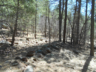
At the mouth of the canyon, at FR728. All pictures are placed in chronological order, heading West. Remnants of the old forest road/spur can be seen as you hike the canyon.
Remnants of the road/spur, just on the other side of the stump
I noticed a significant amount of downed timber, cut by the early loggers. This is puzzling; to leave such a large amount of logs, varying in size yet potentially yielding substantial amounts of lumber. I speculate, based upon the number of cut timber and stumpage, that approximately 10 to20% of the logs were left behind. This is not including the second harvesting in the area, which is identifiable by the style of cutting and the appearance of the stumps. Little was left after the second harvest, as the Forest Service has stringent requirements to haul out the product, and clean up after operations have concluded.
I can only speculate as to why they left what was essentially cash on the ground. Weather can play an important part in the success or failure of a harvest season. One possibility is, the crews felled the silent giants in the waning days of Fall. Winter would have called a halt to the operations; all was left to slumber until the coming Spring. Spring can bring rains, or a sudden melt of the snow, resulting in high water conditions. The roadbed would need to be rebuilt, where washed out by nature. The ground would become an almost impassable morass to navigate, bogging down wagons and horses, and dispiriting otherwise stalwart loggers.
Word would have come from management, who decided that the entire operation needed to be moved to more profitable ground for the coming season. It wasn't worth the cost of keeping the crews on site for what was deemed a few loads of logs. For the owners, profit, efficiency and production were the driving forces to consider.
Years later, as the Forest Service became a notable presence in the woods, the opportunity afforded itself to build a forest road on the old spur. This was not an uncommon practice; it saved time and resources. Thus the foundation was laid for the next timber harvest.
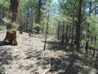
West along the ravine, at the point where the two roads diverge. An open area is just beyond the trees.
The two previous pictures show the road that diverges, ascending the hill to the left. I hiked a short distance on this road, which did not show any immediately identifiable features of being a railroad spur.
The other road as it begins to climb the right ridge. Building methods, such as the rock fill, are indicative that a spur predated the forest road.
What I shall deem the spur as it gradually climbs the ridge.
Construction methods reveal that cut timber was used to provide fill and cribbing along the grade. An additional indication that this was a spur
More evidence of shoring and support using cut timber.
Looking downhill on the grade
At the top of the spur. The area is relatively open and flat, providing the possibility where big wheel logging carts could bring logs to the railhead.
Looking West, across the ravine near the top of the grade.
Looking South across the ravine, from the grade. The canyon narrows, and has numerous rock ledges, thus preventing any building of a spur on the canyon floor.
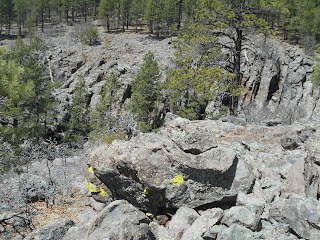
You can get a sense of how rocky and difficult the area can be to hike. This is on the rim of Hell Canyon. Unusual bright yellow lichen on the rock.
High on the hillside, where the ravine merges with Hell Canyon. The ledges are steep and unstable, so be extremely careful. it is about 200 feet to the canyon floor.
In conclusion, I would have to say that this spur was not connected to Hell Canyon, instead was part of the operations out of the Coleman Lake area. The possibility still exists that a substantial line once existed in Hell Canyon; my adventure will continue...
********
One of those serendipitous finds in the forest. A trickling waterfall, mossy rocks, a pool of cool water. A place of rest, sustenance and calm for the forest creatures. Nature at its best.


