BELLEMONT LINE: VARIOUS SPURS NORTH OF BELLEMONT, ACCESSABLE FROM HIGHWAY 180
Recently, due to the late arrival of Fall and Winter rains, I made a concerted effort to explore the far northern reaches of the Saginaw and Manistee's Bellemont Line. Most of the spurs mentioned in this posting are accessible from Highway 180. Be very careful slowing down or turning from this busy road. I suggest studying the information and confirming it with a quality road map. I use Flatline Maps, so some of the forest road numbers may differ. The roads and spur locations can be confusing, as the Saginaw and Manistee tracklayers were very "imaginative" in where they went through the forest.
As a reminder, do not disturb or remove items from historical sites.
Kendrick Springs is one of the remotest areas traversed by the railroad. I included it because I happened to pass by while traveling along FR90.
FR90 KENDRICK SPRINGS
RED designates Saginaw lines in the area. YELLOW designates FR90.
DARK BLUE designates Kendrick Springs. LIGHT BLUE designates Cabin Flat Hill area.

I accessed the area by FR90, heading East from FR144. This route passes to the North of Kendrick Mountain Wilderness. The road can be extremely rough (note the rocks in the photograph), so a 4x4 is a must. It is also advisable to let a loved one know (do you really want to tell your worst enemy?) where you are, in case something happens. It is remote and isolated, so due caution should be observed. At one time it appears that the Forest Service had big plans for this route, as a substantial investment was made on the road. Today, sadly, the road needs updating and truckloads of fill work.
Kendrick Tank, in greener times.
There are a number of concrete structures or foundations in the area.
This is an important watering hole for wildlife and cattle-grazing. Note the tree trunks have a noticeable burnt appearance. There has been a number of fires that have passed through this area, including one after this picture was taken.
Looking North; The roadbed passes by an embankment by the road, and the water tank on the left. The "trickle tank" roof (hence the nickname "trick tank") has been added since the last visit.
Remnants of the spur can be seen along FR90, until the point, where the
road angles off to the west, the spur continuing to the north.
Artifacts along the roadbed. Object is a brake shoe, either off an engine or the drum of a loader.
Leave objects where you find them. Do not disturb or remove items from historical sites.
*************
The next area, covered on the following map, is generally located north of Fort Valley, and northeast of Wing Mountain
RED designates S&M spurs in the area. YELLOW is Highway 180.
PURPLE designates FR9008N Grand Canyon Tank spur.
BLUE designates FR9004N AND FR164C spur
GREY designates FR222B and FR9230R spur
Dotted lines indicate areas of potential spurs,
or areas not traveled in the forest.
(Map courtesy of Google Maps)
FR9008N GRAND CANYON TANK
(DENOTED AS PURPLE LINE ON MAP)
The Grand Canyon Tank and spur can be accessed from FR222B, then turning onto FR9004N.
Further up the road, another forest road, FR9008N (?), turns to the right. Follow it east to the tank.
BEWARE: roads in this area are extremely rough and may be washed out. If it looks too dangerous, then don't drive it. Get out and walk; after all, that is what this is all about. Get outside and get some exercise, and always be careful.
The spur follows the road on the right-hand side. A noticeable ramp takes the spur up a ridgeline, just before the tank. It then heads in the direction of Highway 180. This is looking down the ramp towards the forest road.

looking in the general direction of Highway 180. This section is not drivable.
The spur, as indicated on the map, crosses the highway, then ambles through the forest, until it connects with FR151-Hart Prairie Road. Forest Service maps indicate the spur follows FR151 North for some distance. The road appears to be on the old roadbed.
FR9004N AND FR164C SPUR
(BLUE IN ABOVE MAP)
FR9004N is an old spur, and the road is on the old grade. It ambles through the forest, until connecting with FR164C. It is possible that FR164C is also a spur to the west of the intersection with FR9004N (there are indicators along the road.) The highway is a short distance away to the East. Forest Service maps indicate that the spur crossed the highway, continuing on or near FR151A until it connects with FR151, Hart Prairie Road.
FR222B AND FR9230R SPUR
(DENOTED IN GREY ON ABOVE MAP)
This spur is accessible from FR222B, on the South side of the road. The North side is another forest road that you may think leads to Grand Canyon Tank. It will lead to a steep gully. This road may be closed to vehicle traffic, so you may have to hike in. This spur is one of those serendipitous events, where hiking down FR9230R I found a spur that crosses the road.
Following the grade east on foot will reveal that it parallels, at some distance, FR9002N, which is a pipeline road. This does not appear to be closed to vehicles. The spur eventually goes to ground (disappears) before reaching Highway 180. Don't get lost.
***************
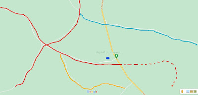
The following map covers an area located midway between Fort Valley and Kendrick Park. The Snow Park recreation area is located nearby.
The FR9009K Spur is designated in YELLOW. RED designates other spurs in the area. BLUE spot is Aspen or Water Haul Tank. FR794 Hart Prairie spur is denoted in LIGHT BLUE.
FR9009K at FR249 SPUR
FR249 is in itself a spur of the Saginaw (marked as RED on the above map.) This forest road passes by Aspen or Water Haul Tank (depending on what map your using: BLUE marks the tank on the above map.) As you approach Highway 180 going eastbound, you can see the original roadbed amble of to the right. The Dotted Red Line indicates where the spur continues East of Highway 180. This area is rugged and not well-marked, and as such is not recommended for travel.

If you are driving eastbound on FR249, FR9009K will be on the right.
FR9009K is well-marked, and either follows or travels on the original roadbed.
The spur continues through the forest, until connecting with FR247.
The road can be rough and rocky.
FR794 HART PRAIRIE SPUR
Although no pictures are available, there is a spur that generally follows FR794 to Hart Prairie (LIGHT BLUE on map.) If I remember correctly, part of the road passes through gated private property. It may be closed; if it is open, stay on the road.


No comments:
Post a Comment