BELLEMONT LINE EXPLORATIONS: SPUR AND GRADE LOCATED ON FR134 AND FR793; BEALE SPRINGS/TANK AREA
Flatline Maps, AZ GMU 7W
SPUR AND GRADE LOCATED ON FR134 AND FR793

RED indicates Bellemont line, along FR171.
BLUE indicates spur, along FR793 and FR134
YELLOW indicates location of rock fill trestle along the grade
FR171 is the main forest road to the area of interest.

The signpost is located at the junction of FR793 and FR171. If you look carefully, you can see where the spur once curved to the east, connecting with the main line on FR171. Head south on FR793; FR134 will be the road to watch for. If you continue on past the intersection on FR793 you will end up at a homestead in Government Prairie.

Along FR134 various artifacts litter the area. The road is built on the railroad grade.

The roadbed becomes better defined as you approach the trestle.

The rock fill trestle is well defined, stretching several hundred feet.

There is a break in the grade, which can be driven around.
It is steep and rough, so a 4x4 is suggested.


The roadbed continues on, curving around the hill above the creek.

Further south, past the rock fill trestle, on FR134. The rock fill grade ends at a gulley, and the best guess is that a timber structure spanned the gap to the other side. Remnants probably exist in the stream bed below the grade. The spur continues along the road, and occasionally there are remnants of the logging operation.


On unusual feature of the area are several rock piles. I have seen the same features along other grades in the forest. Speculate as you may as to what they mean. The road continues south, becoming more 4x4 country.
BEALE SPRINGS/TANK AREA
The Stein Report, prepared for the Forest Service, asked the question if the Bellemont Line connected with the North Chalender Line. At Beale Springs I found clear evidence that the lines once connected at this location. As the Bellemont line was being built, the North Chalender Line was phasing out. It would have made sense that the Bellemont line finished logging the area where the other line ended.
 |
| Beale Tank and Spring area. RED indicates Bellemont line, as it follows FR100 in the Rain Tank Flat area. ORANGE indicates the Beale Tank spur (FR743), part of the Bellemont Line. BLUE indicates the North Chalender line. Most of this section of the grade is on private lands. |

Rain Tank Flat

What appears to be part of the old grade, just to the west of FR100.

Turn west on Forest Road 743 towards Beale Tank. The grade can be seen at times near the road.


Beale Tank area. The grade continues west, entering private land beyond the fence. Although not posted, do not trespass. This grade connects with the North Chalender grade, somewhere on private property. At the tank, the grade is very distinctive; Forest Service maps show another spur on the west side of the hill. The Government Mountain area is covered with ancient ash, under which is a thick layer of obsidian - volcanic glass.

Cut along FR100, heading south past Rain Tank Area. What appears to be remnants of a tie (no longer there.) In the cut I found what I would describe as fossilized charcoal. Apparently, many years before the advent of the railroad, a massive forest fire was created by volcanic activity. Before the forest had completely burned, the eruption covered the area in a thick coat of ash. Thus the layer of burnt material, carbonized in the form of charcoal.

Further West from Beale Spring, at Spring Valley (FR141) and Government Mountain Road area.
BLUE is the North Chalender line, as it connects with the Beale Spring Area.
YELLOW is the Beale Wagon Road Expedition. You can see the trail markings, in the form of a camel, along the road. The Beale Wagon Road generally follows the forest roads in the area. The logging line crosses private property at several locations, and must not be entered without permission.
(The North Chalender Line is covered in separate postings.)
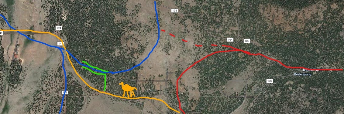
A closer view of the area. Map is for general reference, as roads are not necessarily located along the lines of the satellite image.
BLUE is the North Chalender Line
RED is the Bellemont Line, and the spur to Beale Springs. Dotted line is the spur across private property. Shown is the spur circling the hill, as indicated on Forest maps.
YELLOW is the Beale Wagon Road Expedition Trail.
GREEN indicates FR2461. FR2461 connects with, then travels on the old spur grade.
This forest road is closed to motorized vehicles, but is open to hiking.

Looking west on FR2461, towards FR141- Spring Valley Road.

Cut timber along the spur. Forest is full of stumps and remains of stumps and fallen timber
not worthy of transport to the mill.

Looking East, towards Beale Tank. The line begins to curve to the northeast,
as it enters private property. The area is fenced off and inaccessible without permission.


No comments:
Post a Comment