NORTH CHALENDER LINE; MOUNT SITGREAVES SPUR
AZ GMU 7W FLATLINE MAPS
COPYRIGHT; ALL RIGHTS RESERVED (5/10/22)
Satellite imaging courtesy of Google Maps
The North Chalender Line circles around Sitgreaves Mountain, eventually heading East along Spring Valley Road. The old grade can be seen in several locations, however at this point the grade and the road become one. Spur is located East of Twin Tanks; look closely for FR133; just past that on the south side is the turn off for FR U516 .
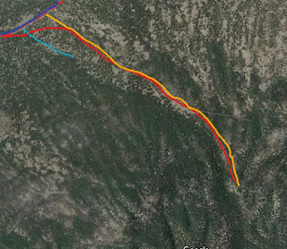
This spur is one of the more predominate remnants of the vast logging operations on Sitgreaves Mountain. Several other spurs once penetrated the flanks of the mountain, yet after 110 years only small, tantalizing sections exist. This particular spur varies from level to a grade that maintains a steady 3%. Near the end, the grade briefly exceeds this. Given the steady and prevailing grade conditions, a standard rod engine would be challenged to maintain traction with a number of log cars. However, a geared engine would not be taxed in servicing the operation. Numerous stumps and the occasional log dot the landscape. Ties and other detritus often left behind by the logging railroad are few and next to extinct. This may be due to the proximity to homesteads in the area, or the efficient removal of items by the grading crews once the spur had served it's purpose. No indications exist of a camp on the spur, but vague outlines along the grade indicate where big wheels once brought the logs to the railhead.
The map is for general reference only. Always consult an up to date road map
DARK BLUE is FR141, Spring Valley Road
RED is the North Chalender Line, including the spur
ORANGE is FR U516, not marked from Spring Valley Road
LIGHT BLUE is FR133
The line just to the south of the road, near Spring Valley Road
Spur at the junction with Spring Valley Road, looking East. This is indicative of what you find in the forest; dirt, overgrowth and little evidence of the grade. I had to walk the spur from FR U516 in order to confirm it's existence. The grade crosses FR133 before intersecting with Spring Valley Road. Perseverance and an abundance of physical exercise will be rewarded.
Very little evidence such as ties exist. This one area is almost unique, in that it indicates the use of logs to shore up the grade. Possible ties are in the picture.
Roadbed located just to the South of FR U516. The roadbed maintains about a 3% grade through the ravine.
Roadbed can become scrambled eggs at several points.
Forest road runs parallel to the roadbed. At one point the road intersects the grade,
and then runs on the old grade for some distance. This is looking West from intersect point
Looking South East from the intersection.
The grade eventually separates from the road,
running higher up on the ridge, south of the road.
looking from the grade towards the road. Area is blackened from a Prescribed Burn. That's the Forest Service term for a controlled fire, as opposed to an
all consuming inferno if the fuel is not burned off in stages.
The road becomes narrow and rough, threading it's way through the trees. At this stage, 4x4 is recommended
The road ends at a rock formation. The area is overgrown, and the trees are falling. Best have full coverage auto insurance. It is quite scenic and literally breathtaking; you are at a high elevation.
Park the vehicle, and follow the trail to the top of the ridge. You will be rewarded with a spectacular view. It is a narrow ridge with steep slopes. This is also a good jumping off point for hiking to the top of Sitgreaves Mountain


No comments:
Post a Comment