Monday, August 1, 2022

AVIATION HISTORY; THE ORIGINAL GRAND CANYON AIRPORT (UPDATED OCTOBER, 2022)

AVIATION HISTORY; THE ORIGINAL GRAND CANYON AIRPORT

This posting is note related to the railroads that existed in the North Country, however it is a point of interest. The vast stretches of seemingly empty desert one sees while traveling to the Grand Canyon hold the treasures of relics of the past, from cultural sites to frontier adventures into the wilderness. 
The development of the aviation industry played an important role in American history. Imagine the early days of fabric covered wooden frames, powered by small gasoline engines, that allowed people to fly in the air. Having developed from those early primitive "aero planes" to the modern jets in just seventy years, this technology is often taken for granted, as you can now board a flight to any destination through-out the world.  
As aircraft designs matured, more individuals began to understand the potential of flight. Small airfields were developed throughout the country, often simple runways plotted out on fields that once grew crops. Rocks and other obstructions were removed, and the dirt fields were marked and developed. Airfields, or aerodromes, were the earliest efforts at designing a facility that would service the needs of the aircraft, as well as provide some accommodations for flight crews and passengers. 
Much has been written on those early days, and more shall be penned in the future. Suffice it to say that this is not a historical treatise on the subject, but a jot-and-tittle about one small, but somewhat significant part of the bigger picture. 
One figure of prominence was Charles Lindbergh. Few know that this larger-than-life individual toured the airfields of Arizona, plotting and planning air routes. His aircraft touched down at airfields in Winslow and Williams, Arizona, and the old Grand Canyon Airport. It should be noted that a fine presentation on his historical visit can be seen at the Williams, Arizona Visitor's Center. More could be presented on the subject, but alas, the local aviation museum has permanently closed. Maybe the Forest Service can provide an exhibition at the Grand Canyon about the persons and places of the local aviation pioneers. 
Recently, I came into possession of a fine book entitled "Scenic Airways, featuring the Autobiography of J. Parker Van Zandt" (copyright 2013 by John Seibold; Hobo Publishing, www. hobopublishing.com.) regarding the early years of aviation in the Grand Canyon area. Mr.Van Zandt was one of the original founders of "Scenic Airways," forerunner of Grand Canyon Airlines. In 1928, two Ford trimotors were purchased for $85,000 each, to begin a sight-seeing airline over the Grand Canyon. This company was one of the first, and the most continuous, scenic airlines in existence. He leased 700 acres from the U.S. Forest Service to develop the original airport. Due to the Great Depression, he sold his interests, and over the years the airline has had a number of owners.  One of those owners was John and Liz Seibold, who developed a scenic airline based in Los Vegas, Nevada. They played an important part in aviation and other industries in the Grand Canyon area, Northern Arizona and Nevada. 
The original Grand Canyon Airport still exists, just North of Valle (Grand Canyon Junction), on Highway 64. It is accessible by Forest Road 305, north of Red Butte. Keep in mind that four-wheel drive is recommended, and you will be entering Forest Service Lands and private property. Do not cause any destruction or disturbance of the site. Even though the forest road provides access, it can be locked-off due to the carelessness of others. This site is known to other blogs on the internet, so it is not a secret.
   

FR305 comes to a fork; take the right road where you can see a gate. The gate can be opened but must be shut when you enter or leave the area.  Cattle roam the area, and ranchers do not take kindly having their bovines scattered across the property.  


You will come over a rise, and then will see the hanger on the left, and the airfield in front. Stay on the road, and it is best stay in the car. Don't enter the structures. The runway is overgrown and not drivable. The area is posted, and there are cameras. The road will circle around the complex. View looking North towards the canyon; there is a ridgeline at the end of the runway. 


Front side of the hanger. Captions above the doors read "Grand Canyon Airlines", and "Scenic .... Airways."


One side of the hanger. In those early days, if you needed to add an office or private bathroom, you just built it. Building code enforcement was virtually unknown.


Back-side of the hanger complex. Sign states "Grand Canyon Airlines"


Looking South from the hanger. 
Charles Lindberg and other notable characters once trod this ground.
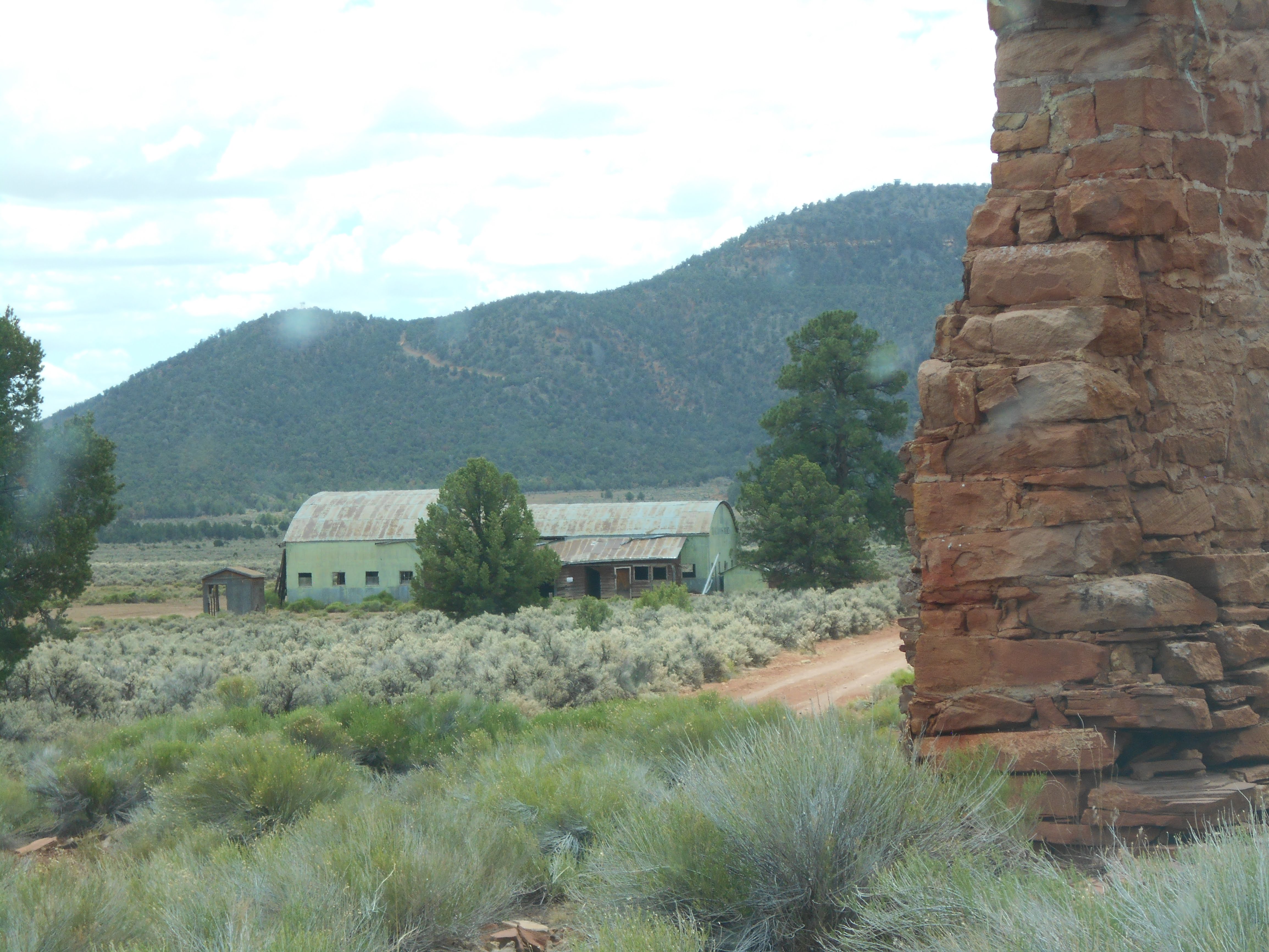

Looking South towards the airfield, from the homestead area. You can see the prominent feature of Red Butte in the distance. In those early days, this airport was built on leased U.S. Forest Service land. As such, obstructions such as mountains and ridgelines were not always the main consideration- locating and leasing land for an airfield was the primary goal. 


A very early design for a dugout home, or storage for supplies. The airfield appears to have been built on an early homestead claim. What is left of these structures could date back to the 1880s.


One of the main buildings next to the airfield. It appears to be built much like a condo, with two separate apartments in the same structure. This at least provided some accommodation for the air crews, or the airfield personnel. Travel to the Grand Canyon Village, with the extravagant El Tovar Hotel, was only a relatively short distance by automobile. In later years, a 1939 Pontiac Station Wagon with  woodie side panels, was used to transport passengers to the National Park. This very same vehicle was found and restored, then placed on display at the Valle (Valley) Airport. The museum is now closed, and most of the collection has been sold.


Tuesday, February 22, 2022

WILLIAMS, ARIZONA: THE LOMBARD GOOD AND COMPANY SMELTER, AND THE ANITA CONSOLIDATED COPPER COMPANY


  WILLIAMS, ARIZONA:  THE LOMBARD GOOD AND COMPANY SMELTER,  
 THE ANITA CONSOLIDATED COPPER COMPANY, AND THE ANITA COPPER COMPANY   

(This appears to be a posting that I had taken off-line to edit but never re-posted. Hopefully I corrected whatever it was that needed attention.)


(Images from Williams, Arizona Sanford Fire Insurance Maps, December 1901: Library of Congress, Geography and Map Division)

THE LOMBARD GOOD AND COMPANY SMELTER


(Images from Williams, Arizona Sanford Fire Insurance Maps, December 1901:

 Library of Congress, Geography and Map Division)

    Notation on map reads: "Located 3/4-mile east of RR Depot. Not in operation Oct. 1901. Iron roofs. Whitewashed inside- water to be supplied from R.R. water supply to a tank to be located on a hill south of plant."

In the early years of Williams, a sense of optimism and the hope of prosperity filled the hearts and minds of the town's citizens. A new lumber mill had been built, with ample supplies of Ponderosa Pines waiting to be harvested. The Atlantic and Pacific ran through the town, with the hope of securing the division point of the railroad. Ranching was a major industry. Add to this the newly discovered mineral deposits of the Anita Mining District, with the promise of untold wealth. Yes, there were ample reasons to hum a happy tune, as there seemed to be no end to good news. The Williams News, the town paper, was more than obliging to continue and encourage this sunny outlook on the future.

      Lombard, Good and Company, through the auspices of the Anita Consolidated Copper Company, were involved in the development of the Anita Mines, north of Williams, and south of the Grand Canyon. In order to ship the ore from the mining district, and to supply the new smelter in Williams, a railroad would have to be built. After acquiring the necessary funding through investors and stocks, they began building the Santa Fe and Grand Canyon Railway to the Anita Mines district, and then onward to the Grand Canyon.  However, due to the fact that the ore deposits were of low quality, the first company ran out of money before reaching the canyon. The Santa Fe Railroad was able to buy the remaining assets of the Santa Fe and Grand Canyon Railway, completing the building of the line to the Grand Canyon. 

    According to one source, the mill was completed June 1898, and the first load of ore was delivered in July of that year. The map indicates that the plant was located 3/4 of a mile from the Williams Depot, situated on a hillside, with the railroad tracks on the southside of the building. The plant building was facing to the north; the main structure included the bin building and a furnace in the northwest corner. A basement is indicated on the east side. Other machinery is not identified in the structure (more on that later). To the south of the building, between two tracks, was the crusher, used to pulverize the ore.
    The Williams News reported on July 12, 1902, that the first test run of the smelter had been completed on Tuesday of that week. This would indicate that the structure had stood idle for several years. Mr. H.I. Nesmith, a representative of the Anita Consolidated Copper Company, had been in Williams for several weeks.
    The smelting was to be a new process, discovered by Mr. W.L. George of Williams. His process required changes to the standing mill (explaining why it was idle for some time.) Due to the application of this new "theory," additional parts were on order. Smelting and mining was not a new industry, having been practiced for hundreds of years. Whenever a "new process" has been discovered, it should be met with some degree of skepticism, meaning hold your wallets closer to your person, as someone may be trying to mine your hard-earned money. It could be presumed that this healthy skepticism was the one thing Mr. Nesmith was in town to sooth.  
   In the December 20, 1902, issue ran a front page, multicolumn article on the Anita Consolidated Copper Company. It expounded the greatness of this moment, when the smelter was about to come into production. Carloads of ore were reported to be bypassing Williams on the railroad, headed east to other smelters. The mines had temporarily shut down, waiting for the smelter to start. Mr. Nesmith was about town, with occasional trips to Boston, and Mr. George was perfecting his process. Large sums of money were being spent. The paper went to great lengths to describe the equipment and smelting process, which it appears as yet had not been fully installed. 
    An important item was mentioned in the article; the ore was of low grade, but they were assured that this could be processed at a profit. Sometimes a fact manages to get mentioned yet could be missed with all of the pontification about possible success.
    The months pass: on January 17, 1903, another article appears in the paper. This too receives front page treatment, albeit a single column. On Wednesday of that week another test run is reported to have taken place. Ore had been treated, then run through the crusher and rolls; "...many fine specimens of pure copper-some as large as a copper cent- were picked up by interested onlookers. The treatment is such that the pure metal is separated from all foreign elements and comes out in quantities varying according to the richness of the ore (italics mine.)"  What is curious about this report is that the metal was pure and varied according to value of the ore, important clues as to the veracity of the company officials. The article mentions that more equipment had to be installed, such as screens, concentrators, and automatic handling equipment.  Some question can be made as to if the smelter had done the work, since the only thing mentioned is that the ore was "treated," then crushed and rolled. Could there have been some sleight of hand at work?
    The company had an agreement with the Atlantic and Pacific to provide water to the mill, however the pipeline was mysteriously damaged beyond repair. It is possible that the railroad had second thoughts about sharing its own precious liquid gold - water.
     Time once again passes. A short article appears on page two in the September 26, 1903, issue. The Anita Consolidated Copper Company transferred all the mine claims and the smelter to Mr. Paul W. Abbot, who then deeded it to the Anita Copper Company. 
    Little is mentioned about the smelter, until 1904. The Williams News reported (02-06-1904, page 2,) that "...It is proposed to move (temporarily) the splendid boilers and engine... (to be) used to furnish power for the hoist, drills, etc..." The new company was going to move these items to the Anita Mines district, in order to drill further down, in the hopes of finding the main ore strata. 
    The newspaper followed-up in the February 13, 1904, edition, with a front-page article: 
"Operations to begin Immediately on Extensive Workings. Anita Copper Company to Thoroughly Exploit the Grand Canyon Mining District for the Red Metal Existing in a Body Below."  

    The article summarized that much labor and time had been wasted, until the reorganization of the new Anita Copper Company. The earlier works in the mining district had been crude, focusing on the surface areas. The ore was assumed to blanket the area, but the new theory was that it originated deep below the surface. The ore that had been found was of such low grade as to cost more to ship than it was worth. This was directed at the Williams smelter, an open admission by whomever that the smelter was not profitable. It was also stated that the last seven years were not looked upon with favor, however new findings in the area brought hope of a potential mining boom. A new mining engineer, Mr. Todd C. Wadsworth of Boston, was brought in to help with the venture. Mr. Wadsworth, with a crew including another engineer, traveled throughout Arizona, and had studied the formations in the Grand Canyon. He was confident that an ore deposit was at the thousand-foot level. 
    The company hired fifteen men to build a dam, 3/4 mile from the mines, hoping to capture two million gallons of water. A large double compartment shaft, with the anticipation of adding an additional compartment, was at the 300-foot level. With regards to the smelter:
    "Within the next few weeks the work of tearing down the old smelter, east of town, will begin, the machinery and timber to be shipped out to the mines and used in the construction of a 500-ton (daily) water-jacket smelter and copper converter, which will turn out blister copper of a 98 per cent grade."
    And so, in 1904, ended the existence of the Williams smelter. History has shown that the promise of a pay layer at the mines did not meet expectations; remnants of a smelter exist in the mining district, but it is doubtful it ever produced.    
       
   When the Anita Consolidated Copper Company transferred all assets to the reorganized Anita Copper Company, the stockholders either had to wait to see if this new adventure would prosper or sell their stock at a loss. When the second company collapsed, so went the considerable investments made by: the citizens of Williams; the Saginaw and Manistee; the J.M. Dennis Company; as well as other investors. The Williams investment alone was over $200,000.  Later, in Federal Court, some of the funds were recovered (Fuchs, 142.) 
        
    The location of the smelter site is now either covered by the overpass on the east end of Williams, or on BNSF property. It is best to leave the site to history; do not trespass on private property. 


Sunday, January 30, 2022

NEWSPAPER ARTICLES (10/25)

 NEWSPAPER ARTICLES


A Common Ad from the early 1900s, appearing in the Williams News 


A page from History; The Williams News
Among the advertisements of the time, and several columns on the Territorial Mining News, an obituary for an unfortunate individual, working for the Saginaw and Manistee logging railroad. Sadly, a pile of logs had given way, crushing the man to death. The logging industry was a dangerous profession, not to be taken lightly. 
(Articles courtesy Williams News, August 10,1902. Arizona State Library, Archives and Public Records Phoenix, AZ.; Williams News, microfilm reel, image 2- Chronicling America, Library of Congress.) 

Tuesday, December 28, 2021

Saginaw and Manistee: WAGES (updated 10/25)

 SAGINAW AND MANISTEE: WAGES

    The company records of the Saginaw and Manistee are very thorough regarding the compensation received by their employees. The comprehensive yearly records cover each classification, wages per each department, and handwritten entries for each employee. From the perspective of a number of sociological and economic disciplines, a wealth of information is waiting to be studied, diagnosed and deliberated.  This chapter is by necessity a limited overview of wage scales, and how the company defined and compensated each employee in the organization. 

    It was not uncommon for owners of the company to have financial investments in other business ventures. The company's Board of Directors were usually selected from a number of different backgrounds, such as banking, railroads and other business pursuits. Often a board member had a seat at the table on other company boards. These were usually successful businessmen, and having access to other "Captains of Industry," exercised varying degrees of influence and status. It was not uncommon, as can be seen in the Saginaw and Manistee's archives, that these titans of industry were well traveled; important correspondence and telegraph messages would find them in San Francisco, Michigan, or Washington D.C. Whatever their title or professional status, all of them had these goals in common; maximize the profits and the return on investments. 

    The logging companies faced a growing number of issues that hindered profitability. Some of these issues were beyond their control, such as newly imposed harvest restrictions by the Forest Service, or the fluctuations in regional lumber markets. Other issues were within their means of control, such as training employees in modern safety methods, thus reducing the workmen's compensation insurance rates. This in itself was a difficult task, as the logging industry has been one of the most dangerous professions in the country. 

    Wages was one of those items which they could control, and this they pursued with all diligence. A common factor that affected all of the companies was the limited number of men willing to do the hard labor required of timber harvesting. It was not uncommon for a worker to begin one day, then move-on the next, as the physical demands of logging were not everyone's dream job. The availability of workers was affected by other opportunities for work in the region. In the earlier years, prior to the start of the Great Depression, work was available in the mines of Jerome or the Prescott area. Agriculture was becoming a major industry in the southern region of the state. There was also the draw of finding a new life in the Golden State of California. It was important to pay good wages, to be competitive and yet not overcompensate. If a skilled employee could find another position with a competitor who was just a train ride away, then you as an owner just lost your investment in that person. For this reason, the logging companies began the practice of cooperating in setting wage scales. 

    For this time period, this may not have been an uncommon practice. The owners invested in the company, creating jobs. As such, management had the responsibility to control costs, one of which was wages. This practice continued for some time, until the workers wanted a seat at the table and a say in operations and compensation. Thus continued the age-old strife between labor and management. This is a topic beyond the limited scope of this chapter. Suffice it to say, the Saginaw and Manistee resolved many of these issues by the implementation of the Safety Committee, where the two sides of the same organization could meet. Yet, whatever the outcome of their cooperation, management maintained a firm grip on wages.    

    It should be mentioned that the Saginaw and Manistee Lumber Company was not an unfeeling and overbearing corporate entity. On the contrary, they had a keen interest in the health and well-being of their employees, as well as the local community of Williams. On December 13, 1918, the employees received a ten percent pay increase, making it the third raise in one year. These were given not by employee actions, but by the company to help off-set the high-cost of living (Williams News.) 

   One of the conclusions that can be determined from the company files is that the regional logging railroads cooperated, if not colluded, in setting wages. Although competitive in nature, for the most part the logging companies had established their own independent domains by purchasing timber holdings and rights to vast acreage in specific areas.  

    The following two documents outline the Wage Scales in effect as of January 1, 1921, through February 28, 1921 (NAU Archives, Cline Library, Special Collections. (Saginaw and Manistee Lumber Company Collection, NAU MS.84, Box/folders 12.428-450; 14.502-507.)


    However, due to economic changes, new wage cuts were instituted on February 28, 1921. In setting the new wage scales, the S&M management used wage comparisons from documents obtained from all of the regional logging railroads. This included the Saginaw and Manistee Lumber Company; Flagstaff Lumber and Mill Company; Arizona Lumber and Timber; and Apache Railway. The new wage scales inferred that all of the listed companies were coordinating their efforts. Additionally, the new wage scales defined the number of hours that specific operations would work: 
Mills and Factories:  10- hour days
Railroads:                  10- hour days
Woods (operations):    9- hour days


Postcard; author's collection

    On September 1, 1921, the Northern Wisconsin Logger's Association met at the upscale Knight Hotel, in Ashland Wisconsin. All of the major Wisconsin Logging Companies were represented. The participants met to discuss and set new wage scales for all of their members. This document found its way into the hands of the Saginaw and Manistee, which infers that they were a confidante of the discussions (MS NO 84, Box 12 of 15; S&M Collection, Employee Records.) The presence of this document gives credibility to the theory that coordination and definition of wage scales was not just regional, such as in the northern Arizona operations, but also to some degree multi-state, as in the meeting of the Wisconsin Logger's Association. 

   As time progressed, new wage scales came into effect. On September 15, 1927, a new scale was implemented; the hand-written notation implies the same scale continued in effect January 10, 1928 (MS NO 84, Box 12 of 15; S&M Collection, Employee Records.) What is also significant, besides the new wages, was the identification of, and the number of employees in, each job classification.


According to the preceding document, there was only one woods engine crew at work. Given the date, this was probably on the Garland Prairie Line.  


    As time progressed, so did the wage scales. New mechanized methods of harvesting created new classifications and also resulted in others being eliminated. The following information was in effect in the Flagstaff companies; similar pay scales would have been in effect for the S&M during the Tusayan operation. 

Per day earnings calculated on hourly pay at eleven hours per day, six days per week (Richmond, pages 114,117):

Choker Setter:  .32 cents per hour;  $3.52 per day.

Tong Hooker:   .38 cents per hour;   $4.18 per day

Cat Skinners:    .60 cents per hour    $6.60 per day. (Tractor driver)

Train Crews on average would earn higher wages, and engineers would be provided family housing. Crews usually began work at 6:00 AM, then worked until 5:00 PM. Skid loaders and engine crews would work another hour (fires banked, engines cleaned and serviced, all made ready for the next day.) 

This went on six days per week, with Sundays off. An hourly logger made approximately $21.12-$39.60 per six-day week. Deducted from wages were $1.05 per day ($7.35 per week) for room and board, including company provided meals. Some classifications received room and board (meals) without charge, as part of their compensation.  If you were a hearty eater, as most loggers were, this would be a bargain considering it was all you can eat. Not including deductions for taxes (if any) and purchases at the company commissary, at the end of week the logger was handed approximately $14.00- $32.00 in pay.  This was after enduring dust, dirt, and long hours felling and hauling the Ponderosa pines.

The employees provided their own clothing, from hat to boots, and the mundane expenses of daily routine. Other items, such as tobacco and comfort items, could be purchased through the S&M Company commissary (at a modest profit, no doubt.) The pay may seem lacking in substance; yet appreciation should be forthcoming for having a job, a steady income, and a place to eat and sleep. During the initial years of the Great Depression, up to one-third of the adult male population were transient.

Tuesday, December 14, 2021

Saginaw and Manistee: Big Wheels and Loading Operations; Steam era Log Trains (Updated 10/25)

SAGINAW AND MANISTEE; BIG WHEELS AND LOADING OPERATIONS; STEAM ERA LOG TRAINS 

        Recently I came upon a treasure trove of historic photographs in the public domain.  All photographs in this post, unless otherwise noted, are courtesy of USDA, U.S. Forest Service, and Coconino National Forest.  

   In the early years Big Wheel logging was a common method of transporting logs. The following series of photographs documents this procedure. 

Once the big wheels are placed near the logs, a little finessing is necessary to make sure they are in the proper spot. Note the spring board over the tongue and axle. This would indicate that this set of wheels is a different design than the slip-tongue system. 
 

    The teamsters are making sure that the load is raised in the proper position. The lift chain has been wrapped under the load, and the tongue is in position to be pulled forward by the horse team. The springboard has been placed in a position to stabilize and support the tongue. Note the one brave soul intently watching the chains that are wrapped under the logs. In today's world, this process would violate a number of safety regulations. Then again, it was a matter of getting the work done as quickly as possible. Sometimes you just got to do what you got to do. Another example as to why logging has, and always will be, one of the most dangerous occupations.

This photograph shows a team pulling the tongue forward, raising the log load and placing it in position to be moved to the railhead. A team of two horses, and two men worked together to move the logs.

    Once the lifting process has been completed, the logs are transported to the railhead and load-out. Note the other set of big wheels trundling in the background. Over and again, this process is repeated until quitting time. That does not mean that the teamster's work is done, as the horses must be led back to the camp, then fed and watered. They took great care of these animals; they worked hard, just like their handlers, and were deserving of their oats and hay. The Loader appears to be a Barnhart machine.
    Barnhart loaders, one of three types known to have harvested in this area, had a curved roof, with a graceful curle above the sidewalls. The early designs had a  fixed boom, secured by a number of braces attached to the structure. Later designs had a boom that could raised and lowered.
                                                                    **************


    A Saginaw and Manistee log load-out, circa 1922, most likely along the Bellemont Line. Engine #3, a side rod locomotive, is in charge of the train. The steam loader is an American Loader.  Russel log cars were used during this time period. The drive mechanism of the loader can just be seen under the loader housing. The small wheels allowed the loader to move from one car to another, on rails mounted on the log bunks. 
    The American Loader had a more boxy appearance. This particular design had an adjustable boom, which was able to move in a lateral direction. Functional, basic and easily patched together after the not uncommon accidents along the line (the third type of loader was the McGiffert, which is pictured in the Collier Logging Museum section.)  
    A large volume of logs is being harvested in this area, thus justifying the Company's investment. It is worth noting the short train, often consisting of about five cars. Once the cars are loaded the train is moved to the main track where additional loaded cars are waiting. The engine then would saunter through the woods to the connection with the Santa Fe Railroad, where the Santa Fe would then take the cars to the mill in Williams.


    There has been some discussion, and certainly a degree of disagreement, as to how the cars were loaded. Were the rails separate and then placed on the log bunks, or were the rails permanently mounted? This photograph is captioned "1928- Log loader on log bunks. Loader traveled on rails, mounted on log cars." This is conclusive evidence that the rails were mounted (spiked or bolted); the loader moved from one car to the other. The log cars appear to be 20-foot Russel cars. Although not a Saginaw train, the operations and equipment are similar. Photograph taken on the Mescalero Indian Reservation, Lincoln National Forest. 

"Loaded train leaving the area."
 The engine is a Heisler locomotive. As can be seen, the loader was brought out along with the train. Tucking the loader near the engine reduced the chance of it swaying and tipping the loads.   


Sunday, December 12, 2021

BELLEMONT LINE: BRANNIGAN TANK TO SEVEN ANCHOR TANK, FR9001N

 BELLEMONT LINE: BRANNIGAN TANK TO SEVEN ANCHOR TANK, FR9001N, 81B 

      The Brannigan Tank area was covered in the March 19, 2020 Post. FR9001N is the spur heading north to the Seven Anchor Tank area. This area is part of Government Prairie, a protected place left to nature. The location blooms during the spring, and in the good years, various wild flowers bring forth their majesty throughout the summer months. "Even Solomon was not clothed with such splendor."  It is also home to a variety of wildlife, such as elk and pronghorn antelope. Traveler beware: the roads across the Prairie can be very rough, and impassable during the monsoon season. 

    The following information may seem "preachy," nevertheless there are people who need to be reminded: please follow directions on posted signs. As stated in other posts, and continually repeated, do not destroy or desecrate historic sites. My posting regarding the Bellemont Line and Camp 2 area remains the same; digging things up and removing items from a historical site can result in stiff fines and imprisonment.  


RED is the spur along FR9001N. The Dotted Red lines are spurs 
indicated on early forest maps. YELLOW arrow points to Brannigan Tank.
LIGHT BLUE arrow highlights Government Prairie. 
BLUE designates spur and loadout area. 

At Government Prairie, looking towards one of the Government Knolls.

A herd of Pronghorn Antelope. Even though thousands of miles away, yet they act just like the antelope of the African plains. Being a nature reserve, the area is rich in wildlife.  

Looking North across a portion of Government Prairie. 
Kendrick Peak is in the distance.


The area of study is accessible by following FR9001N from Brannigan Tank (very rough and rocky in places,) or by taking FR81B from Government Prairie.

FR9001N is either on, or parallels the original spur as it heads north.

Grade and road as it ambles through the forest.


Remnants of the original roadbed, not covered by the forest road. Original construction techniques can be seen; logs were placed parallel to the line of travel, then covered by rocks and dirt to the desired level. Standard gauge trains traveled this line. 

A slight ramp, just to the side of the forest road. At the top of the ramp is a clearing, where the spur diverges from FR9001N  


Part of the clearing, where the spur cuts-off to the East. Thankfully, no one has used this log for their camp fire. Sometimes a downed log may look like a good candidate for a campfire, however it may also be a significant artifact of the early loggers. One-hundred-year-old ties were often consumed by fire, whether it was in a fire ring or in a forest fire. Whatever the case, they no longer mark the path of those early roadbeds, making it a challenge to document their route. Please think first before burning history. 


The spur as it heads Northeast from FR9001N and the clearing.


The spur near the top of the hill, looking back on the line. As you can see, the grade becomes difficult to follow, and you could risk losing sight of it. Be careful and don't get lost. If it looks like you are getting lost, stop, turn around and head back. 


The spur ends at the top of the hill, and there are no discernable features.

Near the clearing, just to the side of where the spur begins, appears to
 be another spur and loadout area

At the load out area, there appears to be a wagon road going up the ridge, probably 
created by the big wheel logging carts. 


Some of the detritus of early logging found along the forest road. FR9001N dead-ends into two other forest roads. One on the left will take you back to Government Prairie. The other one heads east, intersecting with several other roads, and eventually reaching FR171. 
Reference a good forest map for directions.

Saturday, December 11, 2021

North Challender Line: Spring Valley Area; Chasing Logging Unicorns

 North Challender Line: Spring Valley Area; Chasing logging Unicorns

    One of the pleasures of field research is visiting old sites and grades; doing a bit of puttering and hiking, and hopefully gaining some useful knowledge. Once in a while, I return to a place that reveals new evidence, yet does not allow for me to come to some definitive conclusions; it's like finding the prints of the fabled logging unicorn, yet destined never to capture a photograph of the mythical creature.   


    The hunt began in the area of Spring Valley, not far from Section Hill. FR141, Spring Valley Road, jogs around several parcels of private land, then heads further north to intersect with FR144. FR194, the area of interest, heads north from FR141, just before making a left-hand jog across the park. The Saginaw and Manistee North Challender line (RED) crosses this area. The line crosses private property, angles through another ranch, and then crosses FR141. An embankment can be seen just to the East of the road (further information on this area is contained in several previous posts.)
     It would be remiss of me not to mention that the Beale Survey and Wagon Road Expedition traveled through this area. Camels once trod this way. Further information is available on that post. 
    FR194 will take you through an area that is now being used as an unofficial off-road vehicle recreation area. The dirt embankment that carried the line up a hill has now been all-but obliterated. The difference from four years ago is striking- another location where signs of the roadbed will be no longer. Up on the hill or ledge, the road continues, and the railbed is on or parallels the road. A forest road, marked as FR726 or FR2463, is on the left. Both markings were along the route; Map indicates the road to follow as FR2463 (marked BLUE on above map.) This appears to be the original spur, not the main forest road FR194.


The road has all the appearance of a logging spur. Keep following the road to the right. There is another forest road on the left that takes you to a tank in a meadow. Road is probably closed and is very rough. That area is fenced, and the road map shows it as private property.  

You can see remnants of the early logging efforts, 
with numerous stumpages and fallen trees left to decay.   


At the far end of FR2463 (or one sign showed FR2462) where it reconnects with FR194, 
there appears to be remnants of this grade, or maybe another one, in the forest.  


    It is my opinion this spur continued on, heading north on FR194, then FR171, towards Pumpkin Center (RED dotted line.) Just to be clear; Pumpkin Center is largely private property. Don't trespass; people are very protective of their privacy. 
    There is also the possibility that a spur followed FR171, heading west from the Bellemont Line. Pumpkin Tank (designated in YELLOW), has the appearance of a grade nearby.  There are a number of tantalizing, additional clues along FR171, but nothing that I can say is for sure; tracks of my mythical unicorn. 
    I can also speculate that a spur, from the North Chalender Line, crossed the area from the West, and circled Moritz Ridge. Since most of this is on private property, I can only guess using old forest maps. There was just too much of the good timber in the area back then, to disqualify this theory.  
    The ORANGE arrows highlight a location where it appears my unicorn may have trod. As can be discerned from the following photographs, there appears to be a distinct grade paralleling the road.  


The grade appears to turn towards the ridgeline.

In this particular area, it is difficult to find the old stumpage associated with early logging. However, I did locate near the road several stumps that have all the earmarks of this time period. Further along the road, there is a gully, where more evidence such as this exists.   
Is this a logging grade, once lost, but once again found? 


Update to ATSF Postings

 I posted a six-part series on the ATSF in Williams, Arizona. Posting to a Blog can get a little wonky, and as such they are not in order. P...