Sunday, June 20, 2021

SAGINAW AND MANISTEE FLAGSTAFF AREA LOGGING RAILROAD: ALLEN LAKE LINE

     FLAGSTAFF AREA LOGGING RAILROADS; ALLEN LAKE LINE:

 SAGINAW AND MANISTEE LUMBER COMPANY.  

       COPYRIGHT; ALL RIGHTS RESERVED (5/10/22)     

    The Allen Lake Line was located in Flagstaff, Arizona, extending to just south of Mormon Lake. This line became part of the Saginaw and Manistee Lumber Company. Once the operation was closed in Williams, Arizona, the company migrated to the leased mill in Flagstaff. The Allen Lake Line was the main route wherein the company reached the timber holdings south of Mormon Lake. This is normally out of the my research area, but you will soon agree it was worth the trip.  

    On March 1, 1941, the Saginaw and Manistee leased the Arizona Lumber and Timber Company from manager Joe Dolan. The S&M had acquired vast timber holdings in the area of Mormon Lake, and the lease of the AL&T allowed them to harvest these holdings. The Saginaw extended the Howard Spring line, extending it for 14 miles to Allan Lake, located South of Mormon Lake.  With the exception of one spur, the railroad line was served by trucks bringing logs to the railhead. Mechanized logging had replaced the need to constantly relay spurs into the forest. A steady flow of quality timber was provided to the leased Flagstaff mill, and during WWII made a significant contribution  to the war effort. SouthWest  Lumber Mills took control of the AL&T and the Saginaw lease in 1952-53. The next reorganized company, South-West Forest Industries, ran the line until March of 1966 (Kuhn 1981:101; Glover 1965; Stein, Report #19,  page33.) 
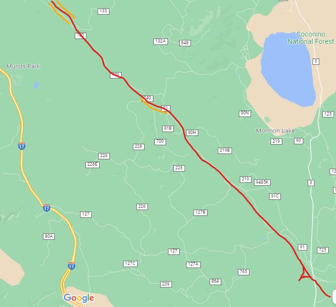


The Allen Lake Line

RED designates railroad grade, as it follows FR91 and FR700. Terminus is south of Mormon Lake, at Howard Spring. Near the end, the satellite view shows a "Y." ORANGE designates canyon area, along FR91A. The area where the trestle is located is highlighted at the top left hand side of the map. 

***
    Today's adventure takes us south of Flagstaff to Mormon Lake area, on Lake Mary Road.  This rural highway is a scenic drive into the vast Ponderosa forests of Northern Arizona. As with all of our travels together, carry a good map, and study it before heading out into the woods. I may be missing a road sign or two, so best be prepared in advance. You should also drive a high clearance vehicle, preferably a 4x4. The road gets extremely rough in places, although there are indications that it will soon be resurfaced.
    We will begin our journey south of Mormon Lake, turning off on Forest Road  91. This means we will be following the logging road back towards I-17 and Flagstaff.  Heading northwest, the road jogs and connects with FR91 and the old roadbed. We will be traveling in a northwesterly direction.  
  

 Where the road meets FR91. Looking West.


A forest road splits to to the left, this is where the roadbed connects with FR91. 


Looking southeast, where the original roadbed heads to Allen Lake. 

This road is marked closed to vehicles. 

 My map calls this Railroad Tank. As viewed from the road, 
you can see an old metal structure. 


A close-up view of the tank site. It does appear that the tank may have been placed upright, but was later knocked over for safety reasons. A large amount of rock work indicates it was an important site, with additional structures.  


        At the tank, a riveted pipe next to a newer culvert 


Further along the grade are other culverts. Several of them are made of metal (iron?) plates, riveted together, giving some idea as to their age. Possibly old tank cars, repurposed as culverts?   


The road continues northwest, running on the old roadbed. 
At this point FR91 is well-maintained


Evidence of logging along the road.


The Logging grade diverges from FR91 to the south side of a park-like meadow. I decided to take the side road, and follow the original grade. My suggestion is continue on FR91, it will save you a lot of time and trouble.   

The grade continues on, then splits (91B or 91C?) into a canyon.
 My map did not show this road.

The grade continued on in a small canyon. HOWEVER, at the far end the road became very rough. Like, stop and get out and remove rocks; move two feet, move more rocks. The kind of area where if you broke down, it would be difficult to get a tow truck. The road did continue, but dead ends into private property. You have to take a connecting forest road to get back on FR91, or go all the way back. Best not try this unless you are very prepared. 

    At Bert Lee Park, the road connects with FR240 and FR700. Take FR700. FR240 will take you right back to Mormon Lake. FR700 is very rough in this area, and it takes a stout steed to ride the broken trail...  


As you continue on FR700, you will begin to see evidence of the grade on the south side of the road.


At several points the rock fill on the roadbed becomes several feet high. 


The forest road crosses a ravine on a fill; if you look carefully 
you will see the railroad grade down below.


The roadbed crosses the forest road, and is now on the north side.  

Look for a side road to the north. Park to the side, and do not block the gate.
The area behind the gate is closed. Just to the right is a creek bed, I walked up it a short 
distance to the trestle (part of which you can see in the photograph.)

The Northwest ramp to the trestle.

Sideview of trestle. DO NOT WALK on this trestle. 


Overview of the trestle. I got this shot from the southeast roadbed, where it is stable.
DO NOT WALK ON THE TRESTLE

The Arizona Lumber and Timber Company built the large trestle in 1929-1930, and was later rebuilt by the Saginaw and Manistee when they leased the line until 1952. Subsequent owners used it until 1966. The trestle structure measures 335 feet long, 30 feet wide at the base, and 22 feet wide at the top. At its highest point it measures 12-15 feet (Stein, Report #19,page 190.) Sections of the trestle have fallen away, revealing the methods used in its construction. The internal structure is made up of logs, cut and placed perpendicular to the direction of the trestle. On top of this, loose fill of rocks were used to complete the core. As it was built up, the sides were tapered to increase strength, then covered in stacked, flat masonry rockwork. It appears that repairs were made, and the structure was widened, again covered in flat masonry rockwork. Stein best describes it as "cribwork trestle with rock fill and facing (pg.191.)" I couldn't have said it better... This monolith is visible on Google maps, satellite view.   


From this side view you can get an idea as to how it was constructed.

The center area has eroded, exposing the core of cut logs used as fill. 

You can clearly see the stacked rocks, and part of the stonework that covered the sides.
 It appears to me that it was expanded and repaired at some point in it's history (probably when the Saginaw leased the line.) 


Close up picture of side stonework.


The southeast ramp.

Close up of construction methods used on approaching ramp.

FR700 continues on for about five miles, eventually ending near Flagstaff and I-17. 
The road generally follows the old railroad grade, which can be seen at several locations. 


Wednesday, June 16, 2021

SAGINAW SOUTHERN LINE AND HYDE HILL AREA, SPUR OFF OF THE BIG SPRING CANYON LINE

 SAGINAW SOUTHERN LINE AND HYDE HILL AREA

RED designates the location of the Big Spring Canyon line, where it crosses the area. 
BLUE indicates the location of the remaining grade North of Hyde Hill. The dotted lines are the best assumptions that can be made as to where the line was located. Camping and the elements have eradicated some of the evidence.
YELLOW marks the Forest Roads. FR139 is the main road running East-West (not marked on map.) FR48 is the north road, that then dead ends into FR 749. This is a popular camping area, and most of them do not realize that a logging spur ran through the area. FR 749 heads east, and other forest roads branch out into the study area. 


If you look closely, their are remains of the spur as it traverses from the open meadow, 
and heads northeast to Hyde Hill.  

Another section of the grade near FR749. The grade crosses the forest road at a wash area, then loops back to cross the road again, then fans out into spurs into the forest south of the road.  

Some of the artifacts found in a camp site. It would be best to 
leave the items in their original location. This helps to identify where the original 
spurs were located.


An embankment, indicating where the grade was, just north of FR749


Thursday, June 10, 2021

COLLIER LOGGING MUSEUM, OREGON; BIG WHEEL LOGGING CART/WAGON

 COLLIER LOGGING MUSEUM, OREGON; BIG WHEEL LOGGING CART/WAGON 

    Nestled in the forests of Eastern Oregon is one of those rare gems of an outdoor museum, dedicated to the preservation and presentation of logging history. The State of Oregon oversees the museum and surrounding trails and campgrounds. Over the years, I have visited this facility, and watched it develop from a storage place for relics of logging artifacts, to a carefully designed presentation of the equipment once used to harvest timber. The artifacts on display include logging carts and wagons, mill machinery, cabins, railroad cars, and all the accoutrements that made logging possible. 


Collier Memorial State Park (located North of Klamath Falls.) You can Web search for additional information. As of May 2021, camping area and trails were closed to repair forest fire damage. The museum is open; however, check the website for hours of operation. 


The museum displays may have changed since my last visit (2019?.) The theme remains the same- an outdoor museum displaying the history of logging equipment from the Pacific Northwest. 


The museum and camp grounds are situated in  park-like setting. Sadly, as of 2021 it has been reported that large areas of forest were burned in this area, including a number of homes. The museum appears to have been saved. 
********
Our main focus at the moment are the Big Wheel logging wagons or carts. Additional information about the museum will follow this section. 


The museum contains one of the largest collections of Big Wheels, with several designs being represented. 


Another view of  a big wheel cart. You can see the lever is in the raised position;  tongue is pulled forward.


The Michigan big wheels were invented by Silas C. Overpack in 1875. He was a wheel right in Manistee, Michigan, who by observing the actions of a local farmer, and the application of American ingenuity,  designed the now famous big wheel logging wagon (technically a cart, since it is based on one axle with two wheels.) Considering that the Saginaw and the Manistee operations and  Mr. Overpack were once  "neighbors" in the great state of Michigan, it is no wonder that the technology was used in Arizona.  
His design -easily recognized by the red paint and highlighted by metal parts painted in black- were used extensively by the logging industry until the 1920s. Equally adaptable to rough terrain or the snow and ice of winter, they could be seen working in the forests from Maine to California, and from Arizona to the Pacific Northwest.   There were other companies that designed and built similar wagons, as can be seen in the museum's collection.

  ( Stein, Pat; Cultural Resources Management; Logging Railroads of the Coconino and Kaibab National Forests; Report Number 19, page 130; United States Department of Agriculture, Forest Service. July 2006 :

Mendocino Coast Model Railroad and Historical Society website: mendorailhistory.org.: Project.geo.msu.edu/geogmich/big_wheels.html.) 


This is a slide tongue wagon, as opposed to a fixed tongue. A slide tongue allowed the horse team to pull the tongue forward, thus raising the log and reducing friction. If they they needed to stop or slow down, the team simply stopped. A lever system and sprockets controlled the log chain, which was placed around the log. It would take a power point presentation to explain it better; best visit the museum and see it for yourself. 


The tongue and mechanism is in the lowered position


A close up view of the mechanism. As the wagons aged and the blacksmiths were kept busy with other chores, often the mechanism was done away with, and the chain was wrapped anyway possible to keep the logs secured. After all, if you're payed by the logs moved to the landing, you find a way to get it done.  


A restored Big Wheel at the front gate. The center disk in each wheel helped reduce the chance of a stray branch or obstruction from damaging the wheels. An early form of a deflector screen; and you thought Star Trek was all science fiction.....  


An example of the evolution of the Big Wheel to the arch type log carrier. This design incorporated changes, including the use of steel in construction. The Tongue has been changed to allow clearance for the logs, while being pulled by a tractor. 


bull dozers, which are caterpillar type tractors ( I say this because a number of manufacturers made these tracked denizens of the forest, not just the Caterpillar Company.), replaced the  horse drawn wagons. A number of variations are on display 


An example of the logging arch and a caterpillar type tractor. The log would have been suspended under the arch. Machines tend not to be too concerned with small or large rocks or uneven terrain, wherein a horse could be pulled-up lame by such conditions. As seen in the prior picture, bulldozer blades on the tractors helped to clear larger obstacles.  As the Forest Service matured, new guidelines were introduced that restricted the use of mechanized logging, thus reducing the long term damage to the forest. 

View of an earlier, simplified arch.
****************


The main visitors center, in the form of a logging structure commonly found in the woods. The best place to begin your visit is at the center, where you can pick up a guide to the outdoor exhibits. 

Inside the center a variety of displays, such as the daily diet of a logger. Food was one of the more enjoyable aspects of logging. A Loggers life was otherwise wake at an early hour, followed by demanding physical labor. Loggers that endured these conditions were often a proud bunch, tough, hardened and took their work seriously. The introduction of mechanized logging techniques helped to increase production, but also introduced new hazards for the logger. New machines usually meant less demand for manpower, however specialized skills required to operate the steel beasts meant higher wages. Cross cut saws and axes were replaced by chain saws, much to the relief of the loggers. However, chainsaws also required constant attention to avoid injury. A logger took special pride in falling a tree exactly where he wanted it. The logging industry is still rated as one of the higher risk occupations for personal injuries. 


throughout the grounds are information signs, giving insight as to the living conditions in the logging camps.  


A very informative timeline as to the evolving changes in logging technology


The museum includes displays representing early living conditions, 
including cabins and small stores.


A single spool, steam powered donkey engine. Donkey engines were used extensively in the Pacific Northwest and California. They also employed several techniques to drag and load the timber that were seldom seen in the South West, such as "highline" yarding. The use of Donkey engines is a bit of a question mark for the Saginaw and Manistee, and requires more research. 


Steam powered mill machinery, common to the larger mills. A boiler house would provide the steam to power the engines. 


A Mc Giffert stiff boom loader. This allowed the empty log cars to pass under the main assembly. As the cars were loaded, they were pulled forward, then the process was  repeated. Loading could speed up resulting in greater efficiency. However, this was not the case for all of the logging operations. The Saginaw and Manistee purchased a used loader from a Flagstaff company, similar to this one, only it was larger and more complicated. The end result was the machine was sidelined. Sometimes the old, tried and true technology works better for your logging outfit. 

   The museum has numerous other artifacts and displays. It is a pleasant and informative stop along the highway, and well worth the visit.   I hope you enjoyed this brief detour from the Saginaw and Manistee Lumber Company. 


The Santa Fe Railway (ATSF) Peavine Route from Ash Fork to Prescott, Arizona: The original grade

 The Santa Fe Railway (ATSF) Peavine Route from Ash Fork to Prescott, Arizona: The original grade (October 2026) Unless otherwise noted, all...