THE BELLEMONT LINE; FIELD RESEARCH AND PLEASANT ADVENTURES
Flatline Maps, AZ GMU 7W
My attempt with this posting is to provide an update on the remnants of the Bellemont Line. A brief history will ensue, followed by basic map directions regarding the specific areas of interest. Always be mindful that all significant sites are protected, and several are designated National Historic Sites. The area surrounding Camps 1 and 2 are designated as such. One person from elsewhere decided to dig on the site, and as a result was caught and prosecuted. They are probably still paying off the fines from such an ill-conceived adventure. Other sites are not marked but are afforded the same protected status. The best policy is leave things alone, enjoy but don't disturb. Any artifact is protected under Arizona and Federal law. For additional historical information, please refer to the Bellemont Line post.

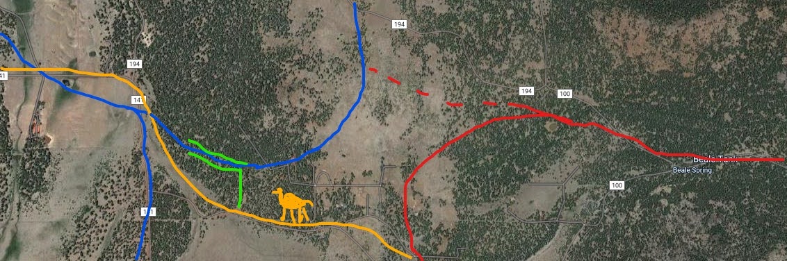
Red designates the Bellemont Line. Blue indicates the North Chalender Line.
For general reference only
In 1903, a new line began construction from Bellemont, Arizona (West of Flagstaff, AZ.) heading north into the virgin timberlands. This line would cover a vast area, larger and more active than any previous lines, with the possible exception of the area south of Williams, Arizona. The line connected with the Santa Fe at Bellemont, then extended north to the Kendrick Mountain area. By 1922 it reached Deadman Wash, the farthest northeast the line reached. Beginning in 1922, as the northern stands were depleted, the operation began to consolidate and harvest the Fort Valley/Wing Mountain area (Stein,35.) The Bellemont would become the longest continuous running operation of the S&M. There is evidence that the northwestern spurs connected with the old North Chalender line (see North Chalender chapter.)
As technology was developed, the company phased-in new innovations. The Bellemont Line was the epicenter of change. Portable camps became standard, most likely replacing the worn-out outfit cars made from old boxcars. Specialized camps were developed, separating logging camps to the far flung spurs, leaving camps like 1and 2 to focus on track construction and engine maintenance (Stein 35.) Like camps 1 and 2, headquarter camps had a more permanent nature, with engine sheds, and maintenance buildings (The Garland Prairie headquarters had underground piped water.) A new camp numbering system was implemented, and as camps were relocated they kept the assigned number, where ever on the line they moved. Horse teams and Big Wheel wagons (carts) were replaced by mechanized wonders, such as tractors and steel logging arches.
The Bellemont Line began phasing out around 1926, and was certain to have ceased before 1931 when the Tusayan Line was operational.
The Line affords the best opportunities to visit, whether as a casual one day adventure or a week of camping and hiking the area. Most of the Forest Roads follow on or near the remnants of the mainline and spurs. FR 171 was built on or parallels the original main grade. The area is accessible from Interstate 40 at Bellemont, or from Highway 180 out of Flagstaff. The main forest roads are reasonably maintained, but a high-clearance 4X4 is recommended. During the winter months, the area is closed. Always carry a good forest road map, and be prepared for rough roads.
BRANNIGAN TANK FR160, FR9205H

Map shows the general route of the spur lines. Red designates logging spurs of S&M. Orange indicates FR1465. Blue indicates Old Route 66, just West of Brannigan Park. The open area is Brannigan Park. Other than the public forest roads, the area is private land.
Leave the locals in peace and respect private property.
Brannigan Tank, just to the south of the pipeline clearing (FR160.) Dating the exact time when this spur was in operation can be difficult. As the Saginaw built the mainline north to Kendrick Mountain, spur lines where laid wherever the timber was ready for harvest. This could date from the earliest timeframe, prior to 1920, or later when the harvesting was consolidated near Wing Mountain. My opinion is that it dates prior to 1920, which when abandoned would allow the west spur to be used as a roadway.
The grade just west of the tank. There are indications of a spur on the east of the tank as well. Could this area be a camp location? Possibly; more research will be done.
South of the tank, a short walk along the roadbed, the spur splits; one heading North, the other turning due West. The west spur continues on, makes a turns south on FR1465, then parallels Old Route 66.
You can walk the grade for about a mile, if you so wish.


The grade is remarkably well preserved, so much so that construction techniques can be seen. This illustrates how the roadbed on the fill was stabilized with timbers laid in the direction of travel. This would also give strength if a creek flowed under the rails.
FR 9205H, north of the tank. Road is located on the other side of the pipeline clearing. The spur/road continues North, ending near Government Prairie. It is extremely rough, requiring four wheel drive. The road is located directly on the logging spur. I walked a short distance along the grade.
***
Further down the west spur, the line turns south. FR1465 being built on a portion of the grade. The stone cribbing and fill work is in remarkable shape. This section is on a steep grade, between 4-6 %. Geared engines, like the Shay, would have little problem negotiating the spur. 
Take note that FR1465 parallels a fence line and private property. Stay on the public land and respect the owners privacy.

Closer view of grade's defining features.
UPPER MCDERMIT SPRING AREA (old Route 66, FR95321)
Red indicates the railroad spur. Blue indicates old Route 66. Map is for general reference only. Exact route of road/spur is more southerly than indicated. I will update map one of these days.
There is little doubt that the West spur from Brannigan Tank reached the Old Route 66 grade, just west of Brannigan Park. Forest Service research maps show the spur in this area. However, I found one curious difference from those maps. A forest road- FR95321- diverges from Route 66, continuing on, skirting the edge of a hill, then looping across a ravine near Upper McDermit Spring. A large, curved rock filled structure was built across the ravine. The grade then continues on until connecting with Route 107, Government Prairie Road. The grade can also be accessed from this direction. The road can be very rough, and is impassable at the ravine. I drove as far as possible, then walked into the location.
Having driven the grade as far as possible, then hiking the rest, one conclusion can be made. The grade has all the earmarks of having been used by vehicles, possibly dating to the earliest highway- predating or having been the original 1920s route 66. To get a better idea of the history of Route 66, visit Parks, Arizona- which happens to be just down the road from our area of interest. There is also a pullout with information boards that better explains the history. Don't forget to visit the general store located on Route 66.
Upon closer inspection, the rock filled trestle that crosses the ravine was built using techniques similar to those used by the Saginaw and Manistee Railroad. At Old Route 66, the West spur from Brannigan Tank could have continued along FR95321, passed over the ravine, and continued on to the Parks area. After the spur was abandoned by the railroad, along comes the County and appropriates, with some degree of appreciation, the grade. It would not be the first time abandoned grades were reused for motor vehicles.
If you plan on visiting the area, be aware that private property borders the road. Be respectful; why not get out of the car, and hike the road? When I find what my computer did with the pictures, I will post them. It's like rummaging through an old shoe box full of photos, never knowing what you come across. Only this time its downloads, files and various programs.
WALKER HILL TANK
The Brannigan Tank spur is about one mile west of Walker Hill Tank, bordering the Transwestern Pipeline Road. Don't try driving between the two points along the pipeline road; there is a section of the road that is more like a cliff, complete with loose rock. On the map posted below, where the Black "X"s are located, the road is blocked by the pumping station.
There is a ridge line to the north of the tank. The tank is located in a park, or meadow. Just to the south the logging spur curves around Walker Hill, then proceeds in a southerly direction towards Spring Tank and Bellemont area. Near Spring Tank, the area is quite flat, and the soil is sandy. This area becomes a quagmire during Winter and Monsoon seasons. The BLACK X's designate where the pipeline road is blocked by the pumping station.
RED designates the logging spur.
DOTTED RED LINE indicates potential logging spur, along the northern end of FR9004N.
YELLOW CIRCLE indicates where the remnants of a grade exists, near FR171C.
ORANGE indicates Forest Roads in the area that are reasonably maintained (FR171E; Pipeline Road). YELLOW indicates where the grade along the ravine is located.
PURPLE indicates short Forest Road, connecting pipeline and FR171E.
One of the more complicated maps I have posted. One of those areas where you need a good forest road map.
On the ridge above the tank, where on the map the red line meets the Orange lines.
Looking South towards the Tank, at the top of the ridge; notice the ravine carved by the
creek. This is highlighted on the map by parallel Orange lines.
Further down the ravine, looking south towards the Tank
A section of the grade, as it approaches from the north to the Tank
Near the section of grade, the area shows signs of having been "landscaped" by the Forest Service. Piles of rocks and debris can be seen, and numerous artifacts have been scooped into the piles.
The grade just before entering the Tank from the north.
Walker Hill Tank
Roadbed as it continues South of the Tank. It crosses the pipeline area, then parallels a small Forest Road, which connects with FR171E. The spur continues on towards Spring Tank. FR9004P appears to be at times directly on the old railroad grade.
This is probably near the intersection of FR171E and the connecting forest road, where the grade curves south. This is highlighted by the Purple line on the map.
Section of spur about one mile south of tank, paralleling FR9004P. There are several sections where the grade is well defined. The line is less defined as it draws closer to Spring Tank, .
One of the more interesting artifacts in the area. This is near another tank along the old grade. A number of interpretations can be made of the item, most certainly it is hand made, and was at one time well constructed for whatever purpose it was intended for.
Square cut nuts, indicating some age to the artifact.
An old kerosene can