SAGINAW SOUTHERN, SAGINAW AND MANISTEE; TULE TANK AREA
(Author's Note: it was with some trepidation that I posted this Blog, since it included the location of a potential historic site. Little did I know that just a few days later, the Rafael Fire raged across the landscape, engulfing some 20,000 acres in just a few days. As the days progressed, the fire slowly grew, where it is now possible that this location was consumed by the flames. The most important thing is that the locals, visitors, and fire crews are safe. It is not worth the risk in human lives to try and save this site. For the valiant fire fighters, I pray for their safety. It does bring to mind how important it is to document and share the information on these sites, as they are fragile and subject to nature's whim (June 23, 2021, 11:30 PM.)
ORANGE circles denote Tule Tank and J.D. Dam. The dam was developed by the Forest Service as a recreation area, with the hope of drawing visitors and campers to the area. It is quite scenic, and there are forest spaces for camping. The lake behind the dam is accessible by several trails.
The Saginaw and Manistee Lumber Company was active over a vast area. Timber rights were held to the far south of Williams, generally spreading east of Perkinsville Road; southeast to the Tule and Saginaw tanks; south to Pine Flat Tank near FR105; north of Bear Canyon, and at Sunflower Flats. According to Forest Maps, there are indications some sections were harvested prior to 1907. Later timber harvests occurred along Pine Flat Road, to JD Dam, and as far south as Bear Canyon in 1935-1937. This would include the areas of Tule, Saginaw and Distribution Tanks.
(S. Sales Kaibab, South End Unit, 7/30/35 (NAU Map 522)).
Further research by the author indicates in this vast area, during the time period (1935-1937), mechanized harvesting was the norm, and the railroad was extant. As much as I would imagine or hope, the railroad does not appear to have operated in this area, with the exception of Sunflower flats.
Tule Tank Area.
Orange line designates original road, north of the tank. Dark Blue designates rock wall area. Light Blue designates camp area and trail from the Tank to the camp.
Tule Tank is located along FR127, about twenty miles southeast of Williams, Arizona. The area is remote, and the roads are reasonably maintained. Although the main forest roads are in reasonable shape, the side roads will often be very rough and difficult to traverse. A high clearance, four wheel drive vehicle is recommended. Hunting and camping are the primary uses for the area, so be aware when entering the woods, and stay a respectful distance from campers.
Normally I do not divulge the locations of camps. I decided to make an exception, partly due to the fact that this area is remote, and in part because temporary forest dwellers (campers) have known about this location for some time. Just remember that it is protected by law like any other site, should be left undisturbed and in its original condition.

The wash, next to the tank. This is looking north east, from the road.
Tule Tank. Above the water and on the ledge is the remains of the early road.
Looking south towards the wash, or seasonal river bed.
Rock ledge, above this is located the remains of a camp or homestead
At the tank, looking at the rock ledge, where a trail or
wagon road climbs out of the wash.
The wagon road as it climbs up the ledge.
At the top of the ledge, the road widens
Rock Wall Area
The rock wall extends across the upper area, from the camp area towards the
wash located in the ravine.
The wall just before the ravine.
Looking across the ravine
There are indications that the wall extended across the
ravine, creating a dam.
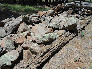
Construction methods used to build the wall. Note the logs
placed parallel to
the structure, and rocks used as fill.
Looking back on the river bed towards the Tank.
The wall is several feet high. Although the intent for building this structure may
be a mystery, there are several clues. One purpose indicates the it was used as a dam,
the other purpose was to backfill the one side, creating a level area, possibly for the camp.
Stop and smell the Cactus blooms.
Upper Camp Area
The site appears to have foundations for three large cabins or temporary structures.
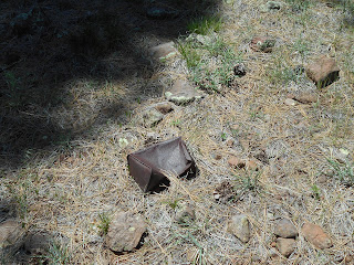
There are artifacts in the area; leave them in place. Can appears to predate 1920.
Original Road Grade
The grade begins just to the north of the tank, and climbs the ridge on the left.
Looking east on the grade
Two views, looking to the west from the top of the grade


No comments:
Post a Comment