CHALENDER MILL AND LINES SOUTH
(Revised and Updated 10/25)

A rare picture, possibly of the Chalender Mill, circa 1893-1897.
Arizona Memory Project: Williams, Arizona Collection. A copy of the original scan
is available at the Williams Historic Photo Project.
The Chalender and Williams Mills were built in 1893. The two sites gave the Saginaw a firm footprint in the regional lumber market. The second mill site at Chalender proved crucial to the survival of the new company. In July of 1896, the Williams mill burned to the ground. This did not deter the investors; by June of 1897 a new and larger mill was constructed on the Williams site. With the new mill, and expanded capacity, the Chalender site was redundant. An unlikely end to an operation that kept the production flowing when the main mill was in ashes.
The question can be made as to why the company did not keep two mills, and expand the Chalender site? Profitability and efficiency of operations was a primary consideration. The second, and more important aspect, was the lack of substantial water sources at Chalender. The Williams site had the potential to harness water for future expansion. Although water shortages were a frequent problem in the early years, eventually the Williams site proved to be the best choice.
Another viable reason is that a competitor mill was situated in the Chalender area. This mill was part of a town that at one time rivaled Williams. Along with the mill, the area was known for ranching and cultivating the sheep industry. Much of what remains have disappeared or are on private property.
In 1894, two spurs penetrated the forests south of the railroad connection. Some discussion has been made as to whom built and ran the lines. The Atlantic and Pacific Railroad was thought to have operated the first spur. However, the Saginaw had the experience and knowledge to operate both (Stein, 31.) It is possible that the Saginaw rented or leased A&P engines, that were then operated by logging crews. The A&P installed the turnouts and the sidings along the mainline, allowing their engines to access the siding and move the loaded log cars.

South Challender Lines (BLUE) connecting with the Santa Fe Railroad at Challender.
Locations are approximate.
The earliest spur appears to have connected with the A&P near present day Sherwood Forest Estates. The line headed south-westerly, then ran southeast across private lands. In this area, little remains of the original roadbed. Several spurs fanned out into the woods. One such spur headed east, crossing FR102 and Isham Spring Creek. The roadbed paralleled FR59, then cut south crossing FR141. It then threaded its way through the hills, exiting from a canyon near Moose Ranch (private property; fenced and posted signs.) Heading due east, the line, according to Forest Service maps, parallel FR139. Some confusion ensues, as further to the east, the line was reconnected by the Garland Prairie Line (built in 1924.) This area has several earth and rock-filled trestles, a short spur and loader landings, all of which could be attributed to the latter connection

Spurs indicated in YELLOW. BLUE indicates Mineral Lake, and Moose Ranch Tank.
The line on the right crosses the trestle in Frenchy Canyon, West of the lake.
The line on the left, possibly the earliest of the two lines south of Challender,
crosses the Moose Ranch heading East. It is this line that the Garland Prairie Line
(Circa 1924) reconnected, spawning additional spurs to the south and west of Moose Ranch
and Rosilda Tank.
.
The Moose Ranch area becomes a very curious area to this amateur archaeologist. Several spurs and connections are located within this domain, but the how and why can leave some degree of conjecture. Add to this, evidence indicates that there was a spur heading West into the Rosilda Spring Canyon, what this amateur has determined as an undocumented spur. More on this in the Saginaw Southern or Garland Prairie chapters.
The second line ran south from a connection with the Santa Fe, passing on the west-side of Mineral Lake, then curving southeast to Frenchy Canyon. The canyon was crossed by an impressive rock-fill trestle. This is located near the end of FR 59. The roadbed continues south crossing FR141, then curves to the west across another, smaller rock trestle. The roadbed ends just north of Moose Ranch.
The mill site is an archaeologically significant historical site. It is still being researched and is a protected site. It is a registered historic sight, and any disturbance can result in severe penalties.
It is a matter of some speculation as when these lines ceased operations. It is possible, knowing the frugal mindset of the owners, that every last viable tree was harvested before they moved on to the next new area. Considering the amount of timber left standing at a distance from the two spurs, it is reasonable to understand the re-connection from Garland Prairie years later.
FRENCHY CANYON TRESTLE
In 1893 the Saginaw Lumber Company constructed a mill at Chalender, Arizona. In addition to the mill, two logging lines were built heading in a southerly direction into the forests. The second of these lines passed Mineral Lake, then progressed to Frenchy Canyon. Nestled deep within the confines of this canyon, rests the remains of one of the earliest, and largest logging trestles for the time period.
As with all travels within the National Forests, I highly recommend a 4x4 vehicle, appropriate preparations for hiking in the forest, and an ample amount of caution. Carry a good Forest Map. Always verify my directions before departing on the adventure. The trestle has protected status, so do not in any way damage the remains.
There are several ways to access the area. The first is to find FR 59 and follow it East as it passes from Isham Spring Canyon, into Frenchy Canyon. The road is rough, however it almost dead ends at the trestle.
The second access, which will involve a moderate hike with the end reward of seeing the trestle, is FR2195, North of FR141-Garland Prairie Road. As you follow 2195, the roadbed is just to the right. You can park and then follow the roadbed. What is unique is that there are approximately 1-2 miles of roadbed with ties. Remember, this section dates from around 1894, so it is a rare treat to see, indeed.
The Trestle itself is approximately 150 feet in length and stands at or just over 10 feet in height (I haven't visited this area for several years, so my estimates could be off. Stop for a moment and consider the amount of effort that went into building this rock-filled structure. The timber had great value to justify the work. In addition to rocks and gravel, they used sections of logs as fill. Whatever was available and practical, they used it to expedite construction.

This is looking North, as you approach the trestle

This is the North approach, looking back over the shoulder.

This is looking North, at the missing section of the trestle.

More of an overview of the trestle.
Note the vast amount of effort that was made to build the structure.

A side view of the materials used in construction. It was not all a haphazard work, but carefully laid stonework was also employed. Given that this was near the top of the structure, this was done to increase stability.

Just past the structure, the roadbed enters a cut.

As an additional treat, there is a second, more moderate in size,
trestle just north of the first
CHALENDER MILL SITE
I will not reveal the exact location of the mill site. One of the many reasons for my reticence is that the site has protected status and is monitored. The Forest Service, and other authorized parties, are conducting research on the site. No artifacts should be removed from the area.
Although in operation for a brief moment in history, the mill site reveals a number of fascinating artifacts. The area covers approximately five acres, so there are a number of features to be studied.

A section of rail firmly planted in the ground.
This rail was probably used as a stop at the end of spur.


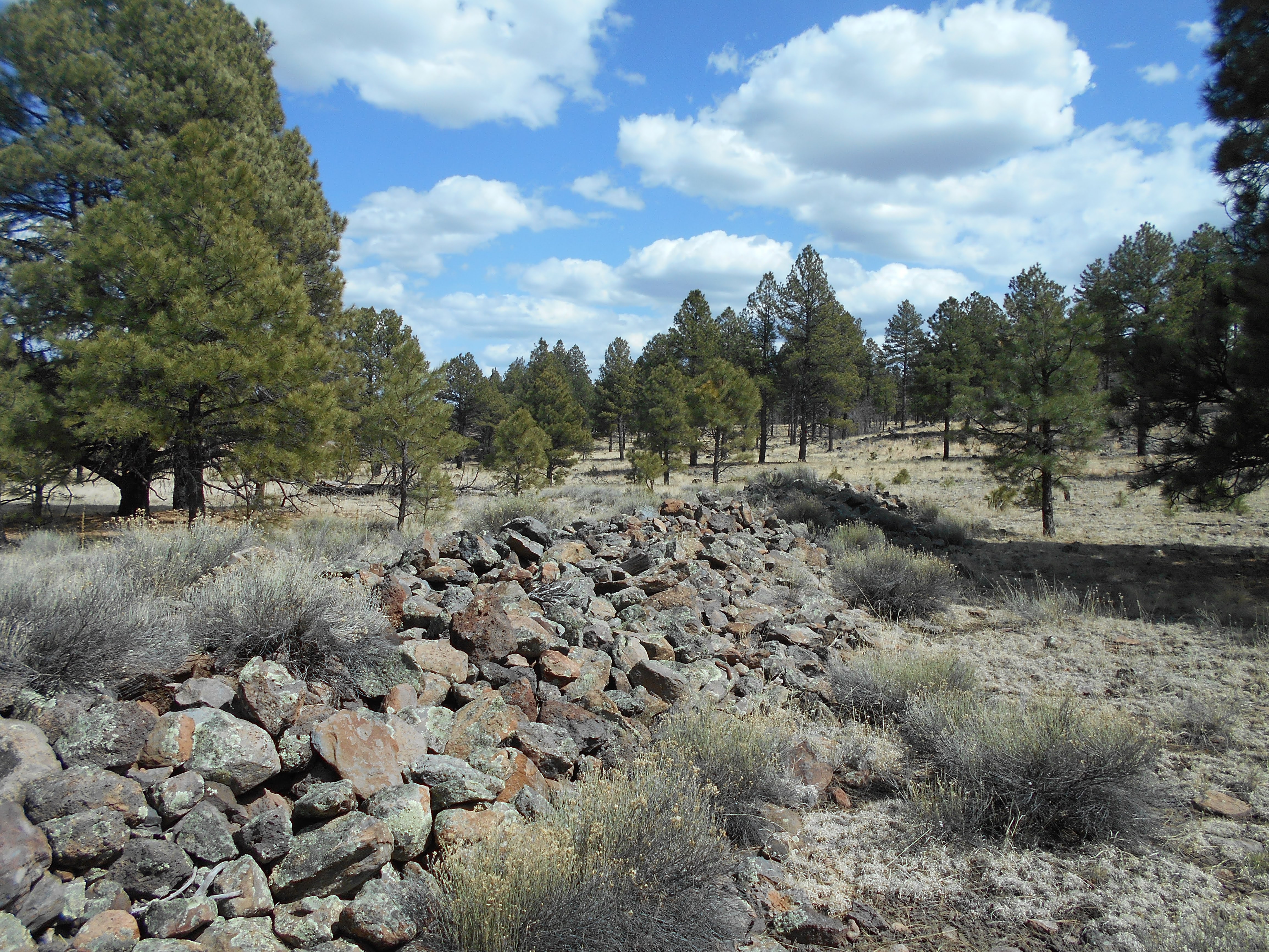
Part of a rockfill, possibly a foundation section, a raised roadbed,
or someone's idea of terraforming

Metal artifact

A second section of rail, used to support the wall structure

Stamping on the first section of rail, dating from the 1890s

Top view of raised structure

Pin, used in link and pin couplers

Possibly broken piece of link, used in link and pin couplers


No comments:
Post a Comment