The Saginaw and Flagstaff, Arizona Operations in 1943
I am continually scanning the internet for additional information regarding the Saginaw and Manistee Lumber Company operations. One area that I will focus on in the near future are the operations in Flagstaff, after the closure of the Williams mill
Bits and pieces of information continue to be found. Recently I purchased an original copy of "The Western Railroader" (published by the Southern California Railroad Club, Volume 6, Number 6 (60); Summer, 1943.) This interesting publication was from one of the many societies and local groups that had formed from the railfan community. The railroad industry, which included logging and traction railroads, were going through major changes. The Class I railroads were transitioning from steam to diesel, and the logging railroads and traction companies were merging or being abandoned. This was all overshadowed by World War II, which placed additional demands upon the country; the need for enlisting able body men and women in the armed forces, and to transport vast amounts of material to the war fronts for final victory.
The railfan community had taken notice of the loss of steam and traction operations, and were becoming more organized, resulting in an era of train watching and documentation which may never again be repeated. One such outgrowth were small publications, some might call "flimsies," which is a slang term given to the written train orders and waybills used by the railroads.
This particular edition had an article, which I will quote in total, on the Saginaw, entitled:
"NEW LOGGING LINE IN ARIZONA OPENS FOR SERVICE
Operating the only logging railroad in either Arizona or New Mexico, Saginaw and Manistee Lumber Co. and Southwest Lumber Mills, Inc., both of Flagstaff, Arizona, in May of this year secured the railroad from the Arizona Lumber and Timber Co. It is now about 26 miles long, extending into the Cocconino (sic) National Forest, with eight miles of new line expected to be built this summer. A 2 1/2 mile section was rebuilt to 1 percent eliminating a switchback and 4 percent grades.
Longe range plans are to eventually build 75 miles of line in about 20 or 30 years to reach into the companies' timber reserves.
Motive power at present includes three locomotives, one of which is a shay. The roundhouse is located at the Southwest mill and the shops at the Saginaw mill are being enlarged to handle the railroad equipment." ("The Western Railroader" (published by the Southern California Railroad Club, Volume 6, Number 6 (60); Summer, 1943.)

It was hoped that the operations would continue for decades, which it did under new ownership and with a number of changes to the aforementioned plan. The article mentioned additional branch lines and rebuilding of the mainline into the woods. What eventually occurred was the use of trucks to haul the loads to the rail line, and then transporting the logs to to the mill site. Other than a few additions and changes, the main rail feeder remained much the same. I did research on this feeder line several years ago, and there were indications of rebuilding in the rock fill structures. It would be interesting to do further field research and find the switchbacks and old right of way. Another project, for another day.
The following is a re-post on the Flagstaff operations:
SAGINAW AND MANISTEE FLAGSTAFF OPERATIONS: 1941-1952

On March 1, 1941, the Saginaw and Manistee leased the Arizona Lumber and Timber Company from manager Joe Dolan. The S&M had acquired vast timber holdings in the area of Mormon Lake; the lease of the AL&T allowed them to harvest these holdings.
The Saginaw extended the Howard Spring line an additional 14 miles to Allan Lake, located South of Mormon Lake. The Allen Lake Line was essentially a steam engine powered, reasonably straight conveyor belt to and from the mill. With the exception of several short spurs and a "Y" near the southern end, the line was fed by trucks. Mechanized logging had replaced the need to constantly relay spurs into the forest. A steady flow of quality timber was provided to the leased Flagstaff mill, and during WWII made a significant contribution to the war effort.
In October of 1944 the Saginaw and Manistee purchased its' first and only 2-6-6-2 articulated mallet locomotive. Not just any articulate, but a true mallet with high- and low-pressure steam cylinders. It had previously been used in the Pacific Northwest. Later, in 1953, it was sold to Southwest Lumber Mills, then scrapped in 1956 (Schuppert, pages 96, 97.)
South-West Lumber Mills took control of the AL&T and the Saginaw lease in 1952-53. The next reorganized company, South-West Forest Industries, ran the line until March of 1966 (Kuhn 1981:101; Glover 1965; Stein, Report #19, page 33.)
..........................
The following is a repost of my field research trip in May of 2022.
FLAGSTAFF AREA LOGGING RAILROADS; ALLEN LAKE LINE:
SAGINAW AND MANISTEE LUMBER COMPANY.
The Allen Lake Line was located in Flagstaff, Arizona, extending to just south of Mormon Lake. This line became part of the Saginaw and Manistee Lumber Company. Once the operation was closed in Williams, Arizona, the company migrated to the leased mill in Flagstaff. The Allen Lake Line was the main route wherein the company reached the timber holdings south of Mormon Lake. This is normally out of my research area, but you will soon agree it was worth the trip.
On March 1, 1941, the Saginaw and Manistee leased the Arizona Lumber and Timber Company from manager Joe Dolan. The S&M had acquired vast timber holdings in the area of Mormon Lake, and the lease of the AL&T allowed them to harvest these holdings. The Saginaw extended the Howard Spring line, extending it for 14 miles to Allan Lake, located South of Mormon Lake. With the exception of one spur, the railroad line was served by trucks bringing logs to the railhead. Mechanized logging had replaced the need to constantly relay spurs into the forest. A steady flow of quality timber was provided to the leased Flagstaff mill, and during WWII made a significant contribution to the war effort. Southwest Lumber Mills took control of the AL&T and the Saginaw lease in 1952-53. The next reorganized company, South-West Forest Industries, ran the line until March of 1966 (Kuhn 1981:101; Glover 1965; Stein, Report #19, page 33.)
The Allen Lake Line
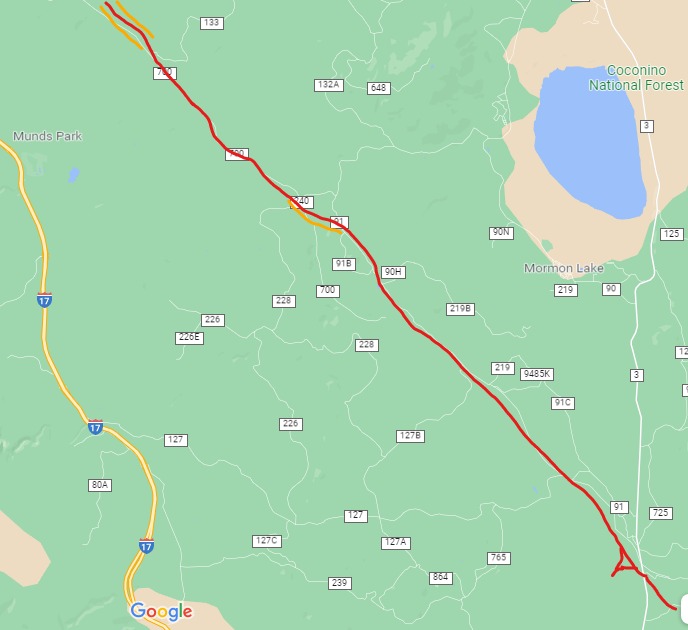
RED designates railroad grade, as it follows FR91 and FR700. Terminus is south of Mormon Lake, at Howard Spring. Near the end, the satellite view shows a "Y." ORANGE designates canyon area, along FR91A. The area where the trestle is located is highlighted at the top left hand side of the map.
***
Today's adventure takes us south of Flagstaff to Mormon Lake area, on Lake Mary Road. This rural highway is a scenic drive into the vast Ponderosa forests of Northern Arizona. As with all of our travels together, carry a good map, and study it before heading out into the woods. I may be missing a road sign or two, so best be prepared in advance. You should also drive a high clearance vehicle, preferably a 4x4. The road gets extremely rough in places, although there are indications that it will soon be resurfaced.
We will begin our journey south of Mormon Lake, turning off on Forest Road 91. This means we will be following the logging road back towards I-17 and Flagstaff. Heading northwest, the road jogs and connects with FR91 and the old roadbed. We will be traveling in a northwesterly direction.
Where the road meets FR91. Looking West.
A forest road splits to to the left, this is where the roadbed connects with FR91.
Looking southeast, where the original roadbed heads to Allen Lake.
This road is marked closed to vehicles.
My map calls this Railroad Tank. As viewed from the road,
you can see an old metal structure.
A close-up view of the tank site. It does appear that the tank may have been placed upright, but was later knocked over for safety reasons. A large amount of rock work indicates it was an important site, with additional structures.
At the tank, a riveted pipe next to a newer culvert
Further along the grade are other culverts. Several of them are made of metal (iron?) plates, riveted together, giving some idea as to their age. Possibly old tank cars, repurposed as culverts?
The road continues northwest, running on the old roadbed.
At this point FR91 is well-maintained
Evidence of logging along the road.
The Logging grade diverges from FR91 to the south side of a park-like meadow. I decided to take the side road, and follow the original grade. My suggestion is continue on FR91, it will save you a lot of time and trouble.
The grade continues on, then splits (91B or 91C?) into a canyon.
My map did not show this road.
The grade continued on in a small canyon. HOWEVER, at the far end the road became very rough. Like, stop and get out and remove rocks; move two feet, move more rocks. The kind of area where if you broke down, it would be difficult to get a tow truck. The road did continue, but dead ends into private property. You have to take a connecting forest road to get back on FR91, or go all the way back. Best not try this unless you are very prepared.
At Bert Lee Park, the road connects with FR240 and FR700. Take FR700. FR240 will take you right back to Mormon Lake. FR700 is very rough in this area, and it takes a stout steed to ride the broken trail...
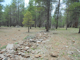
As you continue on FR700, you will begin to see evidence of the grade on the south side of the road.
At several points the rock fill on the roadbed becomes several feet high.
The forest road crosses a ravine on a fill; if you look carefully
you will see the railroad grade down below.
The roadbed crosses the forest road, and is now on the north side.
Look for a side road to the north. Park to the side, and do not block the gate.
The area behind the gate is closed. Just to the right is a creek bed, I walked up it a short
distance to the trestle (part of which you can see in the photograph.)
DO NOT WALK ON THE TRESTLE!
The Northwest ramp to the trestle.
Sideview of trestle. DO NOT WALK on this trestle.
Overview of the trestle. I got this shot from the southeast roadbed, where it is stable.
DO NOT WALK ON THE TRESTLE
The Arizona Lumber and Timber Company built the large trestle in 1929-1930, and was later rebuilt by the Saginaw and Manistee when they leased the line until 1952. Subsequent owners used it until 1966. The trestle structure measures 335 feet long, 30 feet wide at the base, and 22 feet wide at the top. At its highest point it measures 12-15 feet (Stein, Report #19,page 190.)
Sections of the trestle have fallen away, revealing the methods used in its construction. The internal structure is made up of logs, cut and placed perpendicular to the direction of the trestle. On top of this, loose fill of rocks was used to complete the core. As it was built up, the sides were tapered to increase strength, then covered in stacked, flat masonry rockwork. It appears that repairs were made, and the structure was widened, again covered in flat masonry rockwork. Stein best describes it as "cribwork trestle with rock fill and facing (pg.191.)" I couldn't have said it better... This monolith is visible on Google maps, satellite view.


From this side view you can get an idea as to how it was constructed.
The center area has eroded, exposing the core of cut logs used as fill.
You can clearly see the stacked rocks, and part of the stonework that covered the sides.
It appears to me that it was expanded and repaired at some point in it's history (probably when the Saginaw leased the line.)
Close up picture of side stonework.
The southeast ramp.
Close up of construction methods used on approaching ramp.
FR700 continues on for about five miles, eventually ending near Flagstaff and I-17.
The road generally follows the old railroad grade, which can be seen at several locations.