Tuesday, November 23, 2021

BELLEMONT LINE, NORTHERN AREA: CABIN FLAT HILL AND TRESTLE; SECELID TANK AND KENDRICK PARK SPUR

BELLEMONT LINE  NORTHERN AREA:  CABIN FLAT HILL  AND TRESTLE; SECELID TANK  AND KENDRICK PARK SPUR

COPYRIGHT; ALL RIGHTS RESERVED (5/10/22)


    In 1903, a new line began construction from Bellemont, Arizona (West of Flagstaff, AZ.) heading north into the virgin timberlands.  The Bellemont Line would become the longest running operation of the S&M. By mid-year of 1909 the line reached Brannigan Park; Fern Mountain in 1913; Kendrick Park 1917; Howard Seep 1920; and Deadman Wash in 1922.  Documented spurs reached as far north as present day FR9001E and Lava Tank areas.

    The joys of of field research comes with the burden of responsibility. Historical sites can be fascinating in content,  yet fragile in existence. A casual disregard of artifacts can result in disaster for the long term understanding and survival of a protected area. Respectful behavior is a necessity to protect a site. Unfortunately, good behavior and forest manners are learned behavior, and not everyone wants to behave. There are regulations for the National Parks and Forests, Historic sites and Private Property. Destruction or disturbance of historical sites or features can result in severe fines and imprisonment. There are limitations on the use of metal detectors in the State of Arizona. If in doubt, contact the Forest Service office or the local regulatory agency.

    You may or may not encounter historic sites in the area. If you do, leave the area alone. The point of this posting is to show where the roadbed traversed the landscape, not a tour guide for site and relic hunters. leave things as they are, and do not assume you are not being watched or recorded. Many a trail cam is in the areas mentioned, and the Forest Rangers have a habit of sitting in a secluded spot, watching the comings and goings of mere mortals. Don't get  me wrong, I get along (so far) with the Forest Service. They are law enforcement, and they do exist for a reason. 

    A number of surprises were in store for me as I walked and traveled the area. This particular location has several significant features, such as a double-switchback, and several earthen or rock-fill trestles. The terrain varies from rock ledges to grass covered plots; from forests to open grass-covered parks (we called them meadows, but when in Arizona, say what they locals say.) It is also very remote, and the roads can be very difficult to traverse. a high-clearance 4x4, and a good map are a must. 


Blue designates the switchback area. Red designates the "mainline" entering the location.
Yellow is the Secelid Spur. White highlights indicate where the rock-fill trestles are located.    

        CABIN FLAT  HILL AREA 

  This area is designated in Blue on the map. It can be accessed by exiting on FR191C, Then immediately taking FR9111X up the hill. The road may be washed out, meaning you would have to take the long way via FR760 to FR191C into the area. 

The upper switchback lead track.


Remains of the grade as it heads southwest from the top of the hill 
where the first switchback is located.


Looking up the ramp/ trestle from the lower switchback area.


Apologies must be made for the lack of clarity in the photographs as to the 
layout of the roadbed in this area. I just could not figure out what photo was where, 
so a description of this location will have to suffice. 

One of the Forest Service markers in the area. Have no idea what it means.
 While in the area, visit your tax dollars at work 
At the bottom of the incline at the second switchback, looking North. On the left the line is the incline to the top of the hill, on the right the line heads northeast, towards the highway.


The line as it approaches Highway 180. The grade generally follows the highway grade, 
until reaching FR 549 further North. 


SECELID TANK, KENDRICK PARK SPUR AND TRESTLE
This area is designated in Yellow on the second map, Red on the first map.


Take FR9111V south at the intersection. This will take you to Secelid Tank.


FR9111V


Ties and spike next to FR9111V, confirming it is a spur. 
Location near intersection with FR9111X


The southerly spur, as it parallels FR9111V  to Secelid Tank.
Before reaching the tank, the spur climbs a hill and steep grade, 
necessitating a rock fill trestle 


Rock fill trestle along the spur heading towards Secelid Tank. 
The trestle is approximately 100-150 feet long.


At Secelid Tank area, looking South. In the foreground are what appears to be the remains of a water tower and sump. The fence line marks private property and should not be entered.


This spur continues on, curving to the East through Kendrick park,  generally following FR514. Little remains of this spur in that area, however Forest Service maps shows it did exist. The drive along FR514 is worth it, as you can see the North face of the Kachina Peaks. 


CABIN FLAT HILL  TRESTLE
(LATTITUDE 35.428947; LONGITUDE -111.773893)
This area is designated in Red on the map


At the intersection of 9111X and FR9111V.  Picture taken looking North, 
while standing on FR9111V. To the left the road will take you to FR9007F and the large trestle. To the right, the road will take you to the switchbacks and the connection with FR191C. 


The grade crosses FR 9111X, just before entering the ravine at Cabin Flat Hill


Cabin Flat Hill, at the intersection of FR9111X  and FR9007F. Turn left and you will head towards the Cabin Flat Hill trestle.


FR90007F at Cabin Flat Hill, as it heads southeast from a ravine. 


View looking southwest on FR9007F. On the right is the beginning of the Cabin Flat Hill trestle; 
on the left are the remains of a possible spur.


Remnants of a possible spur just to the east of the trestle.


View of the top of the structure. The trestle is some 300 feet in length, 
requiring a great deal of effort to build.


Southeastern approach to the Trestle. This area is marshy when wet, 
and the roadbed is becoming indiscernible. In order to follow the line as it heads south, 
you will have to locate and follow FR9000G. 
This is where you must have a reliable forest road map.


Further South along FR9000G, just before Kendrick Park area.
The line will continue winding south, until reaching Mudersbach Intersection


Thursday, October 21, 2021

SAGINAW AND MANISTEE LUMBER COMPANY: LOGGING OPERATIONS FROM 1936--1956 (Updated 10/25)

 SAGINAW AND MANISTEE LUMBER COMPANY:

 LOGGING OPERATIONS FROM 1936-1956

    The Company did not operate logging railroads from 1936 until 1941, when the Arizona Lumber and Timber operations in Flagstaff were leased (Glover;4; Stein 40.)  The main Mill continued production during this time period, with the box factory shutting down in 1942. World War II played a part in the consolidation of operations, making a more efficient use of resources. 

    The question remains as to how the Williams Mill continued to function without the logging railroads. For more than forty years, the various railroad lines had been the arteries, providing the lifeblood of logs to the mill. All of the wood's engines had now been sold or would soon be scrapped for the war effort.  The mill relied on mechanized logging from timber stands to the south, and the stockpiled logs.

    Since the installation of the Clyde Loading Derrick in 1928, The mill site had the capacity to store some 3 million feet of logs. Presumably, over the years the storage capacity would have been increased.  In 1936, the Great Depression began to wain, but nevertheless its effects would have had an impact on the future planning by the owners. This is one reason why the Company had purchased large tracts of timber in the Mormon Lakes area, south of Flagstaff, and were eyeing the lumber mill in Flagstaff.

    In 1936, the Company had over 100,000,000 feet of timber, estimated to last three years, located south of Williams. They invested in additional Caterpillar tractors, and a fleet of new logging trucks and trailers. This area probably included the vast holdings to the south of White Horse Lake, in the general location of Tule and Saginaw Tanks, extending west to Perkinsville Road. There were additional holdings in the Hell Canyon area, which may have been harvested at this time. Contractors were also used to harvest the timber. After this area was cut, the future would depend on the resources south of Flagstaff. 

       In 1941 the Company leased the Arizona Lumber and Timber operations, located in Flagstaff. Along with the mill came all of the forest operations, including the Allen Lake Line. This was one of the last domains of steam logging railroads in the North Country. The Allen Lake Line was essentially a steam engine powered, reasonably straight conveyor belt to and from the mill. With the exception of several short spurs and a "Y" near the southern end, the line was fed by trucks. 

    In October of 1944 the Saginaw and Manistee purchased its' first and only 2-6-6-2 articulated mallet locomotive. Not just any articulate, but a true mallet with high- and low-pressure steam cylinders. It had previously been used in the Pacific Northwest. Later, in 1953, it was sold to Southwest Lumber Mills, until having been scrapped in 1956 (Schuppert, pages 96, 97.)     

    The average steam logging locomotive can be said to chug its way through the forest, satisfied to rock about the unballasted rails, glad to have a day in the sunshine. A proud little iron horse: at times prancing yet determined as it goes about its work. An articulated, fire-breathing 2-6-6-2 is not just another steam engine. Such a devising of man thunders, shaking earth and sky, loudly announcing its presence; a majestic form casting broad shadows on the landscape, leaving no one to doubt as to what approaches through the cloud of steam and smoke. Such a spectacle, once witnessed, will always be remembered; awesome to behold; urging even the proudest of men to stand in silence, hat in hand, humbled with respect and admiration.  This is no pony; this was an iron-willed stallion at work!


Southwest Forest Industries engine number 12. Engine is on display at 
Arizona Historical Society, Pioneer Museum located in Flagstaff, Arizona 

    Engine number #12 is similar to the original 2-6-6-2 operated by the Saginaw and Manistee during the Flagstaff years. The Saginaw engine was worn out, and after having outlived its' useful life, was unceremoniously scrapped. 
     Engine #12, the second 2-6-6-2 to operate in the Flagstaff area, was donated to the city of Flagstaff by Southwest Forest Industries. After having been moved to to the Pioneer Museum, it is now proudly displayed along the main road. The Pioneer Museum is dedicated to the preservation of the history of early pioneers in the Flagstaff area. This museum has outdoor displays and rotating exhibits located in the main building and is well worth your visit (2340 N. Fort Valley Road, Flagstaff, Arizona; azhs.org/museum/pioneer.) 


Tuesday, October 12, 2021

SAGINAW AND MANISTEE; MECHANIZED OPERATIONS 1928-1956 (10/25)

            SAGINAW AND MANISTEE; MECHANIZED OPERATIONS 1928-1956

    The Saginaw and Manistee Lumber Company was no foreigner to the idea of modernizing operations. Throughout their history, the Company strove to improve and modernize the mill and logging operations whenever it meant additional profit and greater efficiencies. Auditors continually monitored and made recommendations, while the superintendents introduced the new innovations in the woods or at the mill. 

    A major technological shift was taking hold across the United States. The age of the Industrial Revolution was giving way, or more appropriately evolving, into the Mechanized Revolution (so ascribed by the author.) Horses and wagons were soon to be replaced by the automobile for passengers, and the truck for transporting goods. For the logging operations in the high country, the adoption of the truck would spell the beginning of the end to the reign of the iron horse.  

    Starting in 1928, major changes occurred in the wood's operations. The last of the "Big-Wheel" logging horse teams were sold; they were replaced by mechanized equipment.   It is worth noting that in 1930 some horse teams were still in use at Tusayan. A blacksmith and hay car were provided to keep the animals in prime condition. These teams appear to have provided support for the camp, as Caterpillars had taken over harvesting operations.

    At first introduced on a small scale, the evolution to mechanized logging practices began to take hold. Caterpillar model 30 and 60 tractors pulled the logs to the loading sites in the woods. Trucks took over the haul from the south of Williams to the mill complex.  Where practical, trucks hauled the logs to other railroad spurs (Fuchs 23, 273; Stein E-9.)

    As early as 1925, the company was purchasing vehicles. These consisted mostly of used vehicles, such as Ford trucks, touring cars, etc. In November 1928, the S&M began modernizing in earnest, with the purchase of eighteen Model 30 and 60 Caterpillar tractors from Arizona Tractor and Equipment Company (the sales manager must have had a very good day, collecting the sales commission on so many machines.)  In May of 1929 two additional Model 60s were purchased (MS No 84, box 15 of 15, S&M Collection, folder 518, Cline Archives.) 

    The company maintained a good relationship with the Caterpillar brand. However, in December of 1929 they purchased an Allis-Chalmers "75" Logging Tractor for $6482.60. Additionally, a Model "Y" Isaacson Hoist Arch Top was purchased for $1688.40. This may be the first reference of using an arch device to pull logs from the Company's land. According to the records, the purchase of the new Allis-Chalmers was a one-time event. Cats dominated the woods in Saginaw country.

    The Balance Sheet of January 1, 1932 (included in the December 25, 1932, Report) shows the purchase of three Model 60 Caterpillars for $15279.95, and one Adams Leaning Wheel Grader for Railroad (operations) at $2040.00. An interesting entry is for Donations at $418.15, going to various churches and civic organizations. The Company may be frugal, but they did remember their local community of Williams.

    In 1936, the Company spent $63,701.12 on three Caterpillar tractors, twelve White Truck (manufacturer) logging trucks and trailers, and one Ross Lumber Carrier. The Company was then harvesting an area called the "south area operations," and it was lamented that the wet weather had affected production, "a disadvantage over railroad logging, which was the method used by the Company prior to 1936 ( 16th Annual Report, Saginaw and Manistee Lumber Company-1936; MS No 84, Box 12 of 15, pages 4,5; S&M Collection, NAU Archives.) "

   In January of 1937 company records indicate that they owned 12 - 1936 White Truck log bolsters, and 13- homemade semi-trailer bolsters (Box 15, folder 519.) Additional trucks were purchased, with 2 GMC T-23HB trucks in July of 1937. This would indicate that the company had a significant fleet of logging trucks roaming the woods and highways of the Williams area. It would be of interest to find a photograph of one of these trucks.  

Mechanized operations continued until the end of the Saginaw and Manistee Lumber Company. 

The Fordson Tractor, used at the mill. Wikipedia.

The log truck, circa 1937. Courtesy US Forest Service


                                                                        Logging Arch


Various Caterpillar tractors. Collier Logging Museum

Thursday, October 7, 2021

COUGAR PARK, HELL CANYON BRANCHLINE; BARNEY FLATS: Recent Findings and Research

 COUGAR PARK, HELL CANYON BRANCHLINE; BARNEY FLATS

Recent Findings and Research

COPYRIGHT; ALL RIGHTS RESERVED (5/10/22)


        The  spur starts at the intersection of FR3110 and Highway 73 (Perkinsville Road.) Satellite imaging shows the grade crossing Cougar Park, then entering Hell Canyon. This entire region is rugged, steep and challenging to traverse. Evidence indicates, from the numerous stump fields, that a centrally located spur might have existed in the Canyon. 

    Recent research, conducted in the field, and in the climate controlled archives at the Cline Library, NAU, have offered evidence that challenges my earlier view that a line existed within the confines of the canyon.

    Field research, Forest Service maps, and satellite imaging confirms that a line did exist to the mouth of the Hell Canyon; it is a speculation as to how far it penetrated the area. Stump fields exist that tell a story of early logging methods, so some harvesting at an early date did take place. a large stump field exists just to the west of Cougar Park, and additional stumps border the park. throughout the Hell Canyon area stumps indicate early logging activity, so the question remains: when did it occur, and how was it harvested?

    Parts of the area were logged in early years by railroad logging. Spurs do exist, however, they connect with other lines that were operated in the area. One example is the Coleman Lake line, which logged an area to the south of Hell Canyon, including the nearby hills.

    As mentioned previously, the Cougar Park-Hell Canyon line penetrated the area, to an unknown depth. More than likely the steep terrain barred any quick and easy harvesting. What is more plausible was that the area was on government land, and not as yet open for a timber sale. 

    The Audit Report of September 1, 1929 to August 1, 1930 (MS NO 84, Box 15 of 15, S&M Collection, Cline Library) reviewed all of the current operations of the Company. It references truck hauling southwest of the mill (page 8.) These holdings were logged by a contractor by the name of Gibson. It was hoped that 2 million feet of timber would be logged before winter. Some 75 million feet were available, and 50 million could be harvested by truck haul. This would help to answer as to how the mill was provided logs from the time that the South Garland Prairie and the Bellemont lines shut down, and that the Tusayan Line became operational.

        The Sixteenth Annual Report of the Saginaw and Manistee Lumber Company for the year 1936 (MS No 84, box 12 of 15, Cline Library) stated the area south of Williams, with combined Government and Company timber, had holdings of 100 million feet of timber, or 3 years worth of supply. The company had spent $63,701.12 on three Caterpillar tractors, twelve White logging trucks and trailers, and one Ross lumber carrier (pages 4,5.)

    The general area  mentioned was referred to as "South of Williams." This probably included the remaining holdings in the Hell Canyon area,  and the vast  area generally to the south of White Horse Lake, and East of Perkinsville Road. The latter area shows signs of extensive logging. However only truck logging camps have been found, giving credence that this was the domain reserved for trucks and caterpillar tractors.  This is also supported by the Forest Service Timber sale maps.

    To sum up, Hell Canyon had a short spur at one time, not an extensive line into the depths of the canyon. The area was later harvested by mechanized logging, long after the fires had gone cold in the once proud and prancing iron horses. 


Wednesday, September 29, 2021

THE TUSAYAN LINE, SAGINAW AND MANISTEE 1928-1936 (Updated 10/25)

                                  THE TUSAYAN LINE 1928-1936 (Updated 10/25)

Tusayan Area. In the center of the map is Highway 64; the Grand Canyon is just North of this location. Apex is designated on the map to the West. BLUE line designates approximate route of the line. 


The line as it heads Southeast, paralleling FR302. 

Satellite maps courtesy Google maps.

The Saginaw and Manistee was facing a potential shortage of accessible timber to harvest. The ever-voracious mill hungered for the Ponderosa timber. Looking long-term, the company acquired the timber rights to 142 million board feet of timber in the Anita-Moqui (Tusayan) District in 1927 (1928 according to company records) (Stein,37.) This would spawn the Tusayan line, also referred to as the "Canyon tract" in Company records. This was located south of the Grand Canyon, starting at Apex Junction, then headed East along the Coconino Wash. 

 Prior to the beginning of operations, the company built the headquarters camp at Apex, located on the Santa Fe Railroad Grand Canyon Line. The Grand Canyon line, owned by the Santa Fe (ATSF), provided passenger service to the namesake National Park. Stock pens were located along the line to service the livestock for the local ranchers. At Anita, where a small town was built, a spur ran to the mine district.  Apex would be another source of revenue haulage for the Santa Fe. 

     A siding and wye were constructed by the Santa Fe at Apex. The S&M began developing facilities to service the logging railroad. Portable cabins were used, and semi-permanent structures were assembled on-site.  A box car, probably an old camp car on wheels, was used for the school (Richmond, 105-108; 1995.) A gravity fed water system, similar to the one at Garland Prairie headquarters camp, was installed. All that would be left was to bring in the loggers and their families.

    According to the Auditor's Report, authored by C.E. Siddall, for the period of September 1, 1929, to August 1, 1930 (NAU Cline Library Special Collections, MS #84, Box 15 of 15, Taxes and Insurance), Exhibit "A" stated the following inventory was located at Camp 2, assumed to be Apex since it was the Headquarters' Camp:

"2 Baldwin Rod Locomotives #1, #2                    1 Shay Geared Locomotive #4

1 Climax Locomotive #3 (at Williams)                10 Russel Log Cars

2 Fairbanks Morse Speeders                                86 Russel Log Cars (at Williams)

2 Push Cars

1- 7 Room Family House (Wayne Russell, Superintendent?)

1- 4   "         "            "

3- 3    "        "            "

1- 2    "        "            "

1 Cook House                                                        1 Meat House

1 School House (Boxcar?)                                     1 Machine Shop

29 Camp Shacks, Garages, Barns etc.                    1- 8,000 Gal. Water Tank    

1 Fordson with Drum attached                               2 -15,000 Gal. Fuel Oil Tanks 

Bunks, quilts, blankets for 20 men

Track Maintenance equipment for 10 men"

    Several facts can be deduced from the given information. The Company provided bedding (other than sheets and pillows) for the workers. The inclusion of a schoolhouse indicates that families with children were at the camp. It is possible that the common worker, some 20 of them, could have a chance at having a camp shack to themselves- in the woods the shacks were designed for two men. It is also reasonable to assume that the skilled workers, such as foremen and engine crews, were provided a house and the option of a family at camp.  


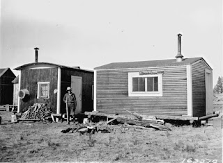
Portable cabins at Tusayan line. Not the simple, standard size. These were probably the two-man, bachelor cabins. Evidently, window and door locations varied with each cabin. Two roof styles are evident; rounded and peaked. The comfort of a wood stove is provided, resulting in hours of relaxing enjoyment- chopping fire wood. Given it was the Depression years, this was a comfortable bonus to be appreciated by those who had employment.

    The S&M was no stranger to innovation, as the company took this time to modernize operations. The Williams mill was electrified. Mechanized logging replaced horses and big-wheels; trucks and caterpillar-type tractors roamed the woods. Portable camps were now the norm.  If it meant increased profitability and efficiency, then the most cost-effective methods were tested and adopted.   

Along with other operational changes, camp numbering was modified to meet S&M practices. When a camp was established and numbered, that operation kept its designation, even when moved. For bookkeeping purposes, it simplified accounting practices. When it comes to archeological and historical research, it can be confusing and requires some time-consuming verification. Camp 36, as well as Camps 1 and 2, were established on the Bellemont, then transferred to the Tusayan line.  In support of this conclusion, the Forest Service Reports indicate there were never 36 camps along the Tusayan Line, and the 1930. 

    Camp 1 was the track maintenance and spur building section of the railroad operations.  It is difficult to confirm if the camp had a base to work from, as it was outfitted with rail-born cars, and would be working ahead of the logging crews, building spurs into the woods.  The camp was outfitted with all the necessary items to build and maintain the line (1930 Audit);

"6 Commissary, kitchen, dining and bunk house cars

2 Tool Houses

3 Fresno Scrapers

2 Plows

Bedding and RR Tools and equipment for 30 men. Cook house equipped for 30 men.

Main Line Track 19.8 Miles; Spur Line Tracks 6.2 Miles" (26 miles total)

A horse-drawn road/grade scraper at work in the woods.

 Courtesy U.S. Forest Service

Steam engines continued to provide the motive power for the log trains. Three engines were purchased or relocated from other operations: two Baldwin 2-6-0s (road numbers 1 and 2); and one Shay (number 4.) (Auditor's Report, 1930.) Engines 1 and 2 were built new for the S&M. Once shiny, stout and strong, the work ahead in the woods would be tough and unforgiving. The engine crews would be proud of their iron steeds, keeping them clean and maintained, despite the dusty and muddy environment (An extensive history on these locomotives is located in the book by Al Richmond, The Story of the Grand Canyon Railway, pages 111, 112.) 

Camp 36 Tank

    Camp 36 was central to the operations in the woods, until the harvesting moved further west of the location. According to the 1930 Audit, Exhibit "A", this was a sizable, well-equipped camp:

 "3-60 Caterpillars with Esco Hoist

2-30           "

1-75 Monarch with Euclid Hoist

4-8 Wheel Wagons

3    Truss Wheel Wagons

10  Work Horses and Harness

Blacksmith Tools and Equipment

2  American Log Loaders

6 Commissary, Supply, Kitchen, Dining and Hay Cars

63 Camp shacks, barns, garages, supply, meat houses

    Bedding and cook house equipment for 70 men" 

    A number of items are worth noting. Given that most references state that the Company had converted to cabins or camp shacks, it is obvious by the inventory that rail cars were still being used for specific purposes. This would expedite the restocking of supplies by rail, as the condition of wagon roads were dubious at best. Given that the railroad was standard gauged, the rail cars could be ferried to and from the mill at Williams.  The six commissary cars were probably used to sell items to the woods crew, and judging by the available number, they supported a very brisk business. 

    It is worth noting that some horse teams were still in use in 1930. A blacksmith and hay car were provided to keep the animals in prime condition. These teams appear to have provided support for the camp operations, as caterpillars had taken over the hauling of logs. 

Clues as to the housing conditions in the remote camps can be deduced from the pictures of the time period. Cabins appear to be small, purpose-built and well-maintained at the start of operations. Trim work and windows appear to be painted in a contrasting color to the main cabin. Form gave way to function; small and simple in design, they provided adequate shelter. Crews were expected to work, not enjoy the comforts of spacious housing. When moved from one location to another, the cabins were designed to be quickly loaded and unloaded from the log cars. 

According to the timber sales maps, the eastern part of the line was harvested first, starting in 1931 (Stein,40.) The Audit Report of September 1, 1929, to August 1, 1930, states that the "Canyon Tract" (Tusayan) had been cutting for a year-and-a-half, placing the start of harvesting in 1928. It is possible that, as soon as the timber was purchased from the Government, fellers were at work in the woods, making ready for the coming of the railroad. The report goes on to state that the costs of the line to date were $148,737.93. Due to the fact that they cut from back to front (farthest first), the mainline extended 19.8 miles with 6.2 miles of spurs.  As the units were cut, operations were moved from east to west. In 1930 the Great Depression began to have an effect on the North Country. The S&M survived the depression years by having control of the harvest rate in Tusayan, the ownership of the mill in Williams, and the foresight to mechanize operations.

    According to the Company's Annual Reports of December 31, 1931, and December 25, 1932, states that the Government Timber Sale was finalized on June 6, 1928. In 1931 24,797,370 feet were cut; in 1932 18,177,350 feet.

By 1936, the Tusayan line had run its course, and management was already eyeing timber holdings in the Flagstaff- Mormon Lake areas. The fires were dropped in the remaining steam engines. Engines #2 and #4 were cut-up for scrap at Apex in 1941. The company did not operate logging railroads from 1936 until 1941, when the Arizona Lumber and Timber operations in Flagstaff were leased (Glover;4; Stein 40.)  

Although the photographs are not captioned as to their location, it is very possible that these were the two engines abandoned near Apex. Probably Shay #4, and locomotive #2. Both were scrapped in 1941. (Photographs courtesy of Arizona Memory Project: Williams, Arizona Collection. A copy of the original scan is available at the Williams Historic Photo Project, in Williams, AZ.)  


******
TOURING THE LINE

Forest road designations change, so consult a recent map for accurate directions. Always be prepared for driving on unimproved roads. If in doubt, don't go out into an unfamiliar area. Remember that all artifacts are protected by State and Federal law. The Map used for this area is designated AZ GMU9.

The main Tusayan Line is reasonably accessible; high-clearance 4X4 is recommended. On highway 180/64, access FR 302 on the right hand side, just past the first roundabout south of Tusayan. The line generally follows the forest road east, from X Tank to Camp 36 Tank. At Skinner Tank area, continue East on FR301A. At the intersection of FR301A, 301 and 317, follow FR301 East to the Camp 36 Tank.


The Line twists and turns from Apex to Ten X Tank, located on FR302. It takes a great deal of old-fashioned tracking skill to follow that portion of the line. This view is looking south from Ten X Tank, as the line reemerges  from the woods. 


The line follows a ravine, passing Charley Tank towards Ten X Tank


Rail left by the scrappers. Remember, it is a protected artifact


In this area, there are approximately one-to-two miles of roadbed with ties.
Ten X Tank has been under development for some time. The new housing will
 be located directly on the old roadbed, and a section of a spur that heads northeast. 
Someday this all may be disturbed, or completely obliterated by development.


Further down the line, the roadbed intersects with MC Rae Tank.


The tank has been expanded directly on top of the grade.


A spur branches off of the line, heading northeast, near FR303

    
    The line enters a canyon, as it progresses towards West Skinner Tank


Camp Thirty-Six Tank, which was expanded directly on the old camp. According to old photographs, there are two roadbeds heading in an easterly direction. The mainline diverges just to the south of the tank, generally heading  along FR307. Further east the line is more difficult to distinguish, considering it is the oldest section of the railroad.  

RECREATIONAL ACTIVITIES

    On the main highway, the community of Tusayan offers a variety of dining and lodging choices. It is a good place to refresh, restock and continue on to your next adventure. The airport provides charter helicopter flights over the scenic wonders of the Grand Canyon.

    The most important attraction of the area, in my opinion next to the remains of the logging railroad, is the majestic Grand Canyon. Plan to spend most of a day, or several days as time permits, enjoying and exploring this natural wonder. Spend time in the Grand Canyon village, admiring the rustic charm of the lodge and Terminus of the Grand Canyon Railway. Always follow the trails, and be mindful not to wander off. A number of people are seriously hurt or die after disregarding the safety railing, or hike in areas that are off limits. Also take plenty of water, and rest often. Altitude sickness, or dehydration  can result in a medical emergency. Stay safe, be respectful, and enjoy your trip.


UPDATES AND RECENT EVENTS

 Summer has begun in Arizona, which means high temperatures and a great deal of staying inside, where the air conditioning is most pleasant....