Friday, October 31, 2025

THE NORTH CHALENDER LINE 1902-1904(6): HARDY HILL SPUR (10/25)

                    THE NORTH CHALENDER LINE 1902-1904(6): HARDY HILL SPUR

From 1902 until about 1904, steam engines ambled through the forests as timber was harvested along the North Chalender Line. The history of the line has been shrouded in mystery, but one thing is certain; timber was the source of profits for the Saginaw, and the Sitgreaves Mountain area grew it in abundance. The market for lumber continued to expand. The mines at Jerome and growing communities needed the lumber for buildings, and timbers to shore up new diggings. Miles of new railbed for the Atlantic and Pacific, merged into the Atchison, Topeka and Santa Fe Railroad (henceforth to be affectionately referred to as the Santa Fe), required carloads of new ties. Even the mill seconds, those ties rejected by the mainline railroads, were used to expand their logging cousins. 

The Saginaw Lumber Company was well-placed to harvest the vast Ponderosa Pine forests, spreading over thousands of acres of land holdings that the company owned or controlled. The company had a large modern mill at Williams and logging railroad lines penetrated the woods. In the first decade of the new century, four separate logging lines owned and operated by the company were either planning, expanding or concluding: the old Saginaw Southern; the North Chalender; the Chalender south lines; and the Bellemont line. The company had to continually develop new rail lines to meet market demands and to feed the voracious appetite of the mill.

All of the lines, with the exception of the Saginaw Southern line out of Williams, directly connected with the Santa Fe Railroad. The Santa Fe was a crucial component in the assembly-line operation: timber was felled, prepped and hauled by big-wheel teams to the logging spur; logs were loaded and transported by log cars to the Santa Fe connection; trainloads were hauled to the mill; timber was cut and shaped into a marketable product; and processed loads were shipped out, once again using the Santa Fe. The now-empty cars were returned to the logging sidings, where the process was once -again repeated. The Santa Fe began raising rates, and as a result the Saginaw considered building their own line to bypass the railroad (See Garland Prairie Line and the Proposed Mainline.)

The management of the Saginaw planned far in advance for their continued existence and profitability of the company. One piece of that plan was the development of the North Chalender Line. Before any rails were laid, many an intrigue took place before the line could be born. 


INTRIGUES, LAND SALES AND GOVERNMENT LAND SWAPS

The early 1900s proved to be a crucial time period for the company. Far to the east In the Halls of Congress, plans were being made to create forest reserves with government oversight and control. Decisions made thousands of miles away began to impact the forests of Northern Arizona. The concept of sustained yield was gaining favor, coming to fruition with the Forest Reserves program. No longer would the harvesting of timber be left to the whims of local control or of logging interests. The Federal Government was about to make their presence known. 

The Saginaw and Manistee had already acquired timber rights for thousands of acres of prime timber. Complicating further harvesting was the legacy of the Railroad Land Grants, dating from the time when the trans-continental railroads were provided Federal land. The land grants were every other plat, resulting in checkerboard appearance on a map.
Company management devised a plan to satisfy their need for timber, and to appease the Federal Government. Why not propose a land exchange with the newly created Forest Service? They would get a continuous, homogenous Forest Reserve, and the Saginaw would get the same for harvesting. This would allow for the building of the North Chalender Line.

Thus ensued a flurry of negotiations and correspondence between the Saginaw, The Federal Government, and Doctor Perrin - owner of the vast land holdings that the other two coveted logging railroads coveted (all correspondence and records hitherto referred to are located at the Northern Arizona University Cline Library; MS NO 84, Box 13 of 15, Saginaw and Manistee Lumber Company, 4(C)2, Folder 457; 1896-1902.)
The Saginaw officials wanted to keep this scheme a secret. It would be advantageous to certain competitors if they found out. Complicating the decision-making process was that officials of the company traveled far and wide, from Michigan to California, with particular attention to Arizona. The standard means of communication were the telegraph and the U.S. mail. Since a telegraph transmission was accessible to anyone with a telegraph office, it was decided to use coded telegrams. At stake were 86,000 acres owned by Doctor Perrin, and possibly the very future of the company.
Negotiations with the Doctor created internal intrigues within the company. Company letters of the time period between officials indicated that they felt the landowner couldn't be trusted and was causing issues. More than likely the Doctor sensed an over-eagerness by the officials to purchase his land, and he was more than likely willing to play one against the other. The building of the North Chalender Line was directly mentioned in the official correspondence.

James R. Fuchs wrote the following regarding Dr. Perrin:
"Dr. Edward B. Perrin became one of the largest cattle and sheep ranchers in northern Arizona. The Perrin Land and Cattle Company owned thousands of acres of grazing land purchased from the railroad, as well as the Baca Grant--a tract of over one hundred thousand acres in Western Yavapai County. Although Perrin--whose Arizona holdings were under the general managership of his brother-in-law, Dr. George F. Thornton--was primarily interested in cattle at first, he soon converted much of his land to the sheep grazing (Page 87.)"

    It appears that Dr. Perrin was a very successful businessman, and as such was a very shrewd negotiator. The company officials were not an easy mark, having built a timber empire in Michigan. It would have been an interesting spectacle to watch both parties play poker in the old west days of Arizona.
In addition to negotiating with the Doctor, the company had to placate the Secretary of the Interior. Legal complications resulted as the government had issues with the transfer of the land titles. No legal sleight of hand was being allowed.  Minor disputes over the minutia of details had to be resolved, such as 1/100 and 10/100 of an acre.    
Finally, in August 1902, all issues were settled, and the land sale was completed. The owner received the purchase price of $4.00 per acre ($344,000.) Then, from September through October, the company in good faith transferred the lands to the government ledger. This resulted in the creation of the San Francisco Mountains Forest Reserve. The Saginaw in return received contiguous timber rights, soon to be harvested by the North Chalender and Bellemont lines. 
The company had rights to harvest the timber until January 12, 1926. This was later extended until December 31, 1950 (Box 13, Folder 458, NAU Special Collections.) On a thirty-year growth cycle, the possibility existed for a double harvest on certain timber tracts. Not a bad deal for all participants, especially the Saginaw and Manistee.

*****************
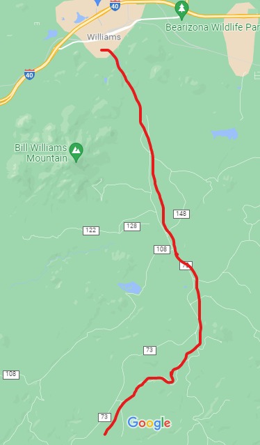
All lines approximate. Courtesy Google Maps


The line connected with the Santa Fe in the Chalender area, then proceeded in a northerly direction through Pittman valley. At the now-designated Radio Hill, the grade began to encounter the foothills of Sitgreaves Mountain, who's peak soars to 9378 feet. Proceeding north-easterly, the grade passed Frenchy Hill, and Hardy Hill. 
     Several spurs once branched off the main line, reaching deep into the timber. Two spurs ventured north of Sitgreaves Mountain, near Little Squaw and Squaw Mountains. It was reported that as part of the lease the Saginaw was required to finish logging these two mountains. The cost of logging this area met or exceeded the profits of the cut timber, due to the ruggedness of the terrain.
The line continued to the east of Sitgreaves Mountain, passing by East and West Elk Springs (West Triangle Tank occupies the lower end of the valley.) This area was once traveled by the Beale expedition, surveying and building a road west to the Colorado River. It is possible to imagine that members of the expedition camped in this area, while camels grazed upon the lush grasslands. Certainly, migrants traveling the road west would have availed themselves of this clear, cool spring water.    

The northeastern reaches of the line are somewhat blurred by the later spurs of the Bellemont line. One question has perplexed the researchers; did the two lines join deep within the forest? According to field research, the answer is yes. One branch of the N. Chalender line (1902-1904) headed east to the remote area of Beale Tank.  A westerly spur of the Bellemont Line (1903-1929) made a direct approach to the same Tank, passing it and continuing further on. The two lines operated concurrently for several years. There are several other locations that indicate they overlapped each other.

The line extended to the Spring Valley area, where a number of spurs covered the region. The Saginaw had long-term rights to harvest the timber tracts. This was a powerful motivation to continue logging the eastern reaches of the North Chalender Line. This also may have played an important part in its demise, as timber could now be hauled on the newer Bellemont line.

HARDY HILL SPUR


At Willow Spring Tank, a spur was laid, running to the west, entering a ravine just south of Hardy Hill. This spur was a unique feature of the entire line, causing much speculation by historians as to its intent. The area continues to be the focus of research for students of industrial archaeology.  
The archaeological evidence shows that the spur was part of a wye near the mainline. A wye would have been used to turn the direction of a locomotive without the use of a turntable. The roadbed encountered a ravine, then opened to the west into a sandy flat area, stretching for several miles. This area provided ample room for whatever the railroad had intended. 
The ravine was walled-in by basalt rock outcroppings, leaving the railroad little choice as to how to descend to the bottom. The problem was solved by building a trestle. This structure was not of an ordinary design; it was simple and functional. The trestle was formed by notched logs, stacked in square columns. The descending grade was adjusted by reducing the height of the stacked logs. Logs were then placed across the top, spanning from one structure to the next. Not a common practice for a mainline railroad, which would normally use bents fashioned from squared timbers and bolted into a bridge structure. After 117 years, the trestle still stands today, albeit showing signs of decay.


This ravine shows an abundance of Native American rock art and is one of three important sites in the region. The other two are Laws Tank (documented by the Beale expedition); and Rock Tank (located one mile north of old route 66, West of the town of Parks.) As indicated by the presence of the rock art, the Native Americans were aware of the spring in the ravine prior to the coming of the railroad. This provides a clue as to why the railroad spur was built.

After descending the trestle, the spur entered the sandy plain area. The Forest Service has concluded that most if not all of the structures in this area are from a later time period. After the demise of the line, this area was covered by an orchard and was privately owned. Remember that it has special protected status, as a cultural and historical site.

Why did the Saginaw access this area by building a trestle? WATER-such as the Native Americans had discovered in the ravine- was needed in large quantities for the thirsty loggers. Most of the camps were located near tanks or springs where horses could be watered.  Locomotives needed constant refilling of their tenders, and the numerous tanks along the line could slake thirsty boilers.  However, good clean, fresh water was needed for the crews and for the cookhouses. Ample supplies would be a necessity given the dry, arid climate. Men do not work long with a belly full of contaminated water.
     A source of clean water would help alleviate the transport of water by the Santa Fe from the Williams mill site. A curious, yet interesting, exchange of letters began in 1903 that may shed some light on the situation (referred to documents reside in the Saginaw and Manistee collection, NAU Chandler Library, special collections.):
On January 9, 1903, Mr. M.J. Drury, Division Master Mechanic, wrote a response to Mr. G.R. Joughins, Mechanical Superintendent of the Santa Fe Railroad, Coast Lines. The letter acknowledges the repair bill, #4540-5, for damage to the Santa Fe Railroad cars 91913 and water car 30065. Notable was reference to the fact that the Saginaw was still using link-and-pin couplers. Life for the rented water car on the logging railroad was hard: the sills were loose and split due to a missing bolt; a side stake pocket was broken; floorboards were damaged by fire; brake beams were broken by a derailment.
 (The Safety Appliance Act made air brakes and automatic couplers on all common carrier, interstate commerce cars, mandatory starting in 1900. The railroad could deny transport of any car not so equipped after this date. The law did not apply to logging or industrial railroads, as long as they did not interchange with a common carrier. It would be interesting to research as to when the Saginaw modified their equipment for the interchange with the Santa Fe.)   
The Saginaw and Manistee rented additional water cars from the Santa Fe. They received another Santa Fe billing on February 24, 1903 (Car Service Department Bill #77.) The logging railroad reportedly rented cars #95313, 99578 for 13 days, having been charged $15.00 during this time period. The Santa Fe had raised their rental rates from $1.00 to $1.50 per day. Also included was the billing for hauling A.T.99578 from Gallup, NM, to Chalender, 210 miles at 10 cents per mile. The total billing was $36.00.
On March 7, 1903, on company stationery, the Saginaw responded to Bills #77 and #139. Bill #77 was returned to the Santa Fe, the Saginaw insisting several errors had been made. The Santa Fe apparently had the mindset to gain as much profit from old equipment: car #95313 was an old engine tender on a flatcar, with a capacity of 2500-3000 gallons; car #99578 held 5,000 gallons. Contending to have been overcharged, the Saginaw argued the correct amount should be $1.00 per day. The additional charge for hauling #99578 was disputed, as no such charge had previously been made.    
On March 16th WM. F. Dermont of the Saginaw wrote the Santa Fe, asking that the $1.00 per diem should be charged for 9,000-gallon cars, not $1.50 per diem for a 5,000-gallon car.  The letter further states that the car is used on the "New branch from Chalender North and cannot get along without a water car inasmuch as the water is at one end of the line while our camps are at the other." He further contended that they should not be charged for Sundays, when the car was not in use.
What can be surmised is that the Saginaw had a daily need for large amounts of fresh water. Apparently, water was available but had to be hauled a great distance to the camps. Renting cars of dubious heritage from the Santa Fe, then being charged for repairs, was causing a strain on profits. Later in company history, the Saginaw apparently purchased their own water cars. 
The water issue could be mitigated if an on-line source of clean water could be exploited. The Hardy Hill spur just might have been the answer to the problem. 
  ........
This is a fascinating area, often studied by student and scholar alike. However, it is a historically significant site that is legally protected. Due prudence and respect should be shown for its historical nature. Access to the remote area can be difficult, and only the experienced hiker should access the site.  
    Another possible reason for the trestle site is that it connected with a spur, which circled around the hills to the south. This would have created a continuous loop to harvest the timber to the west of the mainline.




Thursday, October 30, 2025

SAGINAW SOUTHERN RAILROAD 1898-1909 (10/25)

                     THE SAGINAW SOUTHERN RAILROAD 1898-1909 

(All maps courtesy of Google Maps.)   

  Appears to be 2 Truck Shay #556, and #212 Shay. Both working the line in Barney Flats area, circa 1900. This would be on the original Saginaw Southern.  Courtesy National Archives, neg. 48-RST-4C-2

     From 1866 to the early 1900s, railroad fever had spread across the nation. Several transcontinental railroads were either being built or were in the process of incorporating. The vast frontier attracted farmers seeking fertile ground, ranchers wanting open range to run cattle and sheep, and business interests seeking to develop the vast mineral wealth of the west. These opportunities captured the imagination of more than one corporate boardroom.

    A north-south rail line in Arizona would connect the Atlantic and Pacific and Southern Pacific Railroads. This would expedite the transportation of goods within the state, and open new markets to the outside world.
In 1883, one such route was attempted from Flagstaff, Arizona. Proposed in 1881, the Arizona Mineral Belt Railroad would build south to Globe, Arizona (Schupper 23, 24.) Work began midsummer of 1883 on a tunnel to pierce the Mogollon Rim. By September, the money had run out. Additional funding was provided, but by 1887 the project was $30,000 in debt (Schupper 29,30.) On December 4, 1888, the remaining assets were sold at auction. Renamed the Central Arizona Railroad in 1889, the financial panic of 1893 brought this plan to an end (Stein 7.)

    The Santa Fe, Prescott and Phoenix Railroad (SFP&P) was chartered on May 27, 1891. This would connect Ash Fork to Prescott, Arizona, and eventually reach Phoenix. Construction began on August 17, 1892, from the Atlantic and Pacific at Ash Fork, Arizona. This was quickly completed, allowing transportation by rail.
  
The new Williams mill needed timber, and the company looked south to the vast timber holdings waiting to be harvested. The Saginaw Southern Railroad was incorporated as a common carrier railroad on September 22, 1898.  This would shorten the haul of products from the high-country mills to the burgeoning markets of Prescott and Jerome.  Whether this can be considered an overreach by a logging company with aspirations to becoming a major player on the railroad map, is a subject for debate. At a minimum, if the line failed as connecting route, it would still allow access to the vast timber holdings. Whatever the outcome of such debates, it proved to be a bold move by a conservative group of investors. 
    Another plausible theory as to why the line was proposed was to access the timber south of Williams as quickly as possible. Incorporating a common carrier railroad would allow condemnation by imminent domain of private property. In order to incorporate, you need a starting point and a destination, hence Jerome was the stated goal. This may have been the pretext, which would allow the Saginaw to reach the timber holdings as quickly as possible. Jerome was just a cover for the real intent and purpose of the rail line. 
As a common carrier, the Saginaw Southern was allowed to condemn private property for the right of way. Any disputes had to be resolved in court (Stein 31.) The wagon haulage of logs to the mill would be replaced by the railroad. The new railroad had aspirations of reaching Jerome, and possibly Prescott, AZ. (Fuchs 144.) One early map, dated July 23, 1918, showed a proposed route south from Williams connecting with Perkinsville, along the Verde River (map with letter, July 23, 1918, NAU Cline Library special collections.)**
The Saginaw Lumber Company decided to proceed south from Williams with all speed. Work began in earnest during the fall of 1898. By June 30, 1899, three locomotives were running over 6 miles of track. Just past the Barney Flats Area, the railroad grade encountered obstacles not unknown to experienced construction crews (These were men who had learned their trade in the Michigan forests.) Canyons, hills, and marshy meadows were given their due consideration, then were overcome by tried-and-true methods.
The route of the Saginaw Southern. The original grade generally follows 
Perkinsville Road, until diverging on FR 354. The grade ends abruptly 
at the edge of the pine forests

The grade intersected the old Overland Road, an 85-mile wagon road stretching from Flagstaff to the Fort Whipple-Prescott area. In use from 1863-1882, it was used by the military and civilians to travel to and from the nearby settlements. Vast herds of sheep were moved along the road from the valley to the summer grazing areas in the high country. At one time there were three separate seasonal migration trails leading into the high country.  An old-time forester once said that records indicated some 175,000 sheep passed by in one year on just one trail. The road was less traveled when the grading crews came to the area.
The old Overland Road would have been known to the surveyors, and to think that they used part of the trail by coincidence would be unlikely. The old road provided access from Summit Tank, through a narrow canyon, descending a steep southerly grade of about 3%, and to the northeast of Davenport Knoll. The line would then curve to the northwest of the Knoll (now private property), reaching Davenport Tank. From there, the line headed in a southerly direction, trying to make the best of the difficult terrain until abruptly ending somewhere south. The Saginaw Southern had been outdone by a poor survey, and the relatively easy route of the already built SFP&P.


Overland Road, Davenport Tank Area. 
RED designates the route of the Saginaw Southern.
 BLUE is Davenport Knoll. 
ORANGE indicates the steep grades and canyon area.


Forest Road as it heads south to the canyon.                                 Historical Sign

Davenport area. 
                    
One question remains; why didn't the railroad continue on to the far-flung horizon, namely Jerome? Later reports, circa 1921, stated that the railroad had chosen the worst of surveys, causing a financial strain (Stein, 31,91.)  The area for many square miles is studded with steep hills and rock-strewn gulches. Geared locomotives, such as Shays then in operation, would have had little trouble traversing the steep canyon grade. Shays have remarkable traction, but they are also slow in operation. The canyon is a seasonable dry wash; the monsoon season's torrential rains would devour the roadbed at will.  Efficient and safe operations would be jeopardized by the challenges of a difficult survey. 

  Rumors of extensions occurred in 1901 and 1909 (Fuchs 144.)  The railroad would have to justify the cost of expansion by providing some other source of revenue, besides logging. Laying rail through the Verde Canyon, to the productive mines of Jerome might be the answer. This hope was soon dashed, as the Verde Valley Railroad built through the Verde Canyon to Clarkdale in 1911-1912 (Wahmann, 21.) This effectively cut off any hopes of any further southward expansion. One can imagine that the company retreated to higher ground, where quality timber stands could be harvested. 

    Further south on the remnants of the line, the quality of timber became dubious. Old cut logs still exist, revealing knotty snags, not worthy of hauling to the mill. South of this point, the proposed grade entered the juniper forest zone, sparsely dotted with small mines.

With all hopes of expansion having been quashed, the operation reverted to the everyday mundane task of a logging railroad. It is also possible that people (including the newspapers) continued to refer to the old line by its former name, long after the legal identity had ended. The length of the line fluctuated, until in 1904 when the line was first reported abandoned (Glover; Stein, 31.) The rail bed reached no further south than section 29-T20N, R2E. This would be in the area of Deadman Wash and May Tank. (Stein 31.) 
 
It is possible that the corporate identity of the Saginaw Southern ended in 1904 or 1909. To abandon the status as a common carrier at an earlier date would cause problems for any chance of future expansion. The Williams News proudly proclaimed in their banner that the Saginaw Southern was an entity well into 1912. Local residents would have referred to the southern line by its original name, just as they referred to the mill as the "Saginaw" for many years to come.
    If the Saginaw Southern was revived as a common carrier entity, then the company could once again exercise condemnation rights on private lands. In1921, they attempted to revive the rights with the Arizona Corporation Commission, at a time when an all-Saginaw East-West mainline was being proposed (Stein, 37.)
Additional information, supported by archaeological evidence, indicates that a robust and active presence of the logging railroad existed beyond 1904. It was reported that 3 locomotives of the Saginaw Southern were working south of Williams in 1908 (Fuchs 181.) 
.....
The Saginaw and Manistee Lumber and Timber Company was active over a vast area to the south of Williams, with timber rights generally spreading west of Perkinsville Road; southeast to the Tule and Saginaw tanks; south from Williams to Pine Flat Tank near FR105; North of Bear Canyon, and West of Sunflower Flats. According to S. Sales Kaibab, South End Unit, 7/30/35 (NAU Map 522), There are indications on the maps that some sections were harvested prior to 1907. 

    Later timber sales occurred along Pine Flat Road, to JD Dam, as far as Bear Canyon in 1935-1937. Further research indicates in this specific area and time period mechanized harvesting and trucks ruled the roads. 
.......
A document has been uncovered: A congressional Bill that would allow the Saginaw Southern to proceed south to Jerome crossing the Forest Reserve. This would acknowledge that the railroad had initially surveyed to Jerome (55th Congress, 3rd Session; House of Representatives Report #1674 ((H.R. 11061)) December 14, 1898.) This document was viewed on eBay, appearing to have been torn out of a Congressional Ledger. The author does not purchase documents that have a suspicious pedigree or provenance. 
Further, the author has viewed a document in the N.A.U. archives for what appears to be a work order/ request for quote on a narrow-gauge Shay. This is further evidence that the Saginaw was seriously considering a line to Jerome, or a connection with its narrow-gauge railroad.


Tuesday, October 28, 2025

THE PERMANENT RAILROAD STATIONS OF WILLIAMS, ARIZONA (UPDATED 08/26.)

  THE PERMANENT RAILROAD STATIONS OF WILLIAMS, ARIZONA (Updated 08/26)

The Atlantic and Pacific Railroad officially arrived in Williams on September 1,1882. Prior to that there would have been construction crews working feverishly to prepare the roadbed for the track to be laid, and the building of various structures related to the railroad. 

The early history of stations and related depots in Williams, Arizona is somewhat murky. The published document authored by James Fuchs shows that even this author struggled with all of the sometimes-contradictory information that was contemporaneous for the time (Fuchs, James R. A History of Williams, Arizona 1876-1951; University of Arizona,1953. Internet PDF version available on-line.)
Most of this confusion stems from the definition of whether Williams was designated as a passenger district, and does that mean that accommodations were built at the onset of operations. Later, the Santa Fe stated that Williams was always considered a passenger district, as well as for freight. There are several indications that a passenger station was built in 1884, and another saying 1890 (Fuchs, pages 50,51;65; 70,71.) 
In support of the 1884 date, Herbert Wisbey (A History of the Santa Fe in Arizona to 1917; University of Arizona) states that Williams was a "Supper stop for west-bound passengers on the railroad and a breakfast stop for east-bound passengers (page 51.)" This would indicate that the wooden eating house and station complex existed at that time.

The author's statement has been that a boxcar first served as a temporary station until a more adequate depot was built. I cannot quote a certain source; it is like a fever, you know you have one but cannot define where you got it from. So, it is with historical research. However, in viewing the early primitive conditions from the existing images in Fuch's writings, it can be assumed that a box car would have been in use.
    
My research indicates that there were four permanent stations or depots that have served Williams:

 The wooden station complex indicated on the Sanborne map dated 1892
 Brick Depot, 1901-1908. Restored as the Williams Visitor Center.
 the Frey Marcos Harvey House, March 10, 1908-Currently in use for the Grand Canyon Railway.
 The Williams Junction station site; December 18, 1960-1969.

THE 1892 STATION COMPLEX

     
    The December 1892 Sanborn Insurance Map reveals the earliest permanent station complex at Williams. This complex was located to the north of the tracks, West from 2nd Street. The complex includes offices, a separate railroad depot, and a separate station dining room that included a pantry and kitchen. According to Richard Meltzer's book "Fred Harvey Houses of the Southwest"(Images of America series, Arcadia Publishing,) in 1894, Fred Harvey "took over the operation of a restaurant" that had serviced passengers since 1884. This was more than likely the aforementioned restaurant. 
  In the early years of railroad passenger travel, dining services were less than desirable. After a successful experiment with one of the railroad's establishments, the Santa Fe contracted with Fred Harvey to manage all of their restaurants and hotels throughout their system. Through the efforts of Mr. Harvey, the Santa Fe was known for quality services that every traveler could enjoy from Chicago to California. 

    The map is significant, in that it defines the footprint of the accommodations built prior to the brick station. These structures likely were wooden buildings erected to provide basic facilities for the railroad.  Just south is a men's sleeping dormitory. Additional buildings are a water tower, pump house, and a basic engine servicing facility. All of these structures have been lost to time.  

THE 1901 BRICK STATION AND FREIGHT HOUSE

 A reasonably sized brick passenger station was built circa 1901, on the Atlantic and Pacific mainline in Williams (later the Atchison, Topeka and Santa Fe Railroad.) This was probably the replacement for the old wooden structure possibly dating to 1884. With the opening of the Frey Marcos Hotel and station complex in 1908, the brick station was redundant. 
As the new station complex was being built, the City of Williams petitioned the Santa Fe to place a vehicle crossing over the tracks at Third Street. They countered with the offer of placing it on Second Street, to which the city agreed. This meant that the station had to be moved to its current location sometime prior to 1910. 
This resulted in the main north entry to the downtown area passed the red-light district. This may not have been what the city fathers intended; then again times were different back then.


(Sanborn Insurance Maps, Library of Congress Collection)

December 1902 shows the brick station to the North of 2nd Street, across the tracks. In order for 2nd to be extended, the station had to be moved 

This 1910 map shows the brick station moved to the current location, making way for the extension of 2nd Street, becoming Grand Canyon Avenue. This also provided direct access from the new Harvey House complex to the downtown area. 


Image: postcard, author's collection. 
View of the relocated station, circa 1960-70s. The stoplight no longer exists; it is now a three way stop-sign intersection.  The location is at the intersection of Grand Canyon and Railroad Avenues, diagonally across from the original "Red Light District" (maybe the streetlight had a different meaning?)


    Before, and after the move, old depot remained abandoned for some time, until a group of dedicated volunteers restored the depot, becoming the Williams Visitor Center. The interior walls were left exposed, so that you can see the brickwork and other details of construction. In addition to being a historic building in its own right, the center offers travel information by a friendly and well-informed staff. A small but well-designed museum provides the visitor with a glimpse into the history of Williams.

THE FRAY MARCOS HOTEL AND STATION COMPLEX

The Santa Fe entered an agreement with Fred Harvey to operate their restaurants, which he did with exceptional and legendary skill. The Author Richard Meltzer wrote an exceptional book on the Fred Harvey houses ("Fred Harvey Houses of the Southwest"; images of America Series; Arcadia Publishing.) According to him, the Fray Marcos Hotel and Restaurant was opened in Williams on March 10, 1908. The name honored Father Fray Marcos de Niza. The interior was decorated with Native American style art and western styled furniture.  


Two views of the then new station complex. The station and restaurant can be seen in the first image; the expanded hotel complex in the second (Postcards; Author's Collection.)


Maps 2 and 4, both dated October 1910, shows the location of the new station, Harvey House restaurant, and the relocated brick station. At one time, railroad housing extended east from the station towards the 2nd street crossing. All of this area is now paved and concreted-over.


Early photograph of a train arriving at the Williams Station complex (Arizona Memory Project; Williams Arizona collection.)

A photographer (based upon the camera and associated gear in the picture) trying to cavort with two Harvey Girls, near Williams. The women do not appear to be totally comfortable with the situation, as the man might be just a bit inebriated. The women were expected to be of good moral character, and any violations could cause immediate dismissal. 
(Arizona Memory Project; Williams Arizona collection.)


A contemporary view of the station and hotel complex, owned and operated by the Grand Canyon Railway. The new hotel is located behind the station.
........
    There was also a third permanent station near Williams, at a place called Williams Junction, located East of town. After the realignment project of the 1960s, this junction is where the Prescott line and the mainline merged, then proceeded east towards Flagstaff. The area where the station was located is on BNSF property, and off-limits to the public. 


Postcard: Author's Collection


    The following summarizes a well-written article on Wikipedia, I have included Author's notes:

"Williams Junction was an Amtrak station, that serviced the Southwest Chief, and passengers to the Grand Canyon (Author's note: although this refers to the original station that was built on this site, there are indications that the original was replaced by an "Am-shack," a basic metal bus stop like structure well known for simplicity and uncomfortable conditions. Local historians dispute that an Am-shack was located at this site, instead passengers were unceremoniously dropped off at night on a concrete platform.) 
    There were two separate routes for the Atchison, Topeka and Santa Fe from Williams; one was the transcontinental route that ran East-West, and the other was the route that ran South to Prescott (the "Peavine Route.") Originally, both routes passed through Williams, in front of the Williams- Grand Canyon station. (Author's note: the Peavine Route pre-1960 merged with the mainline at Ash Fork, Arizona.) Later, as the trans-con was realigned, the junction was moved to the east of Williams, which became known as Williams Junction. This station opened on December 18, 1960. In 1969, at the end of Santa Fe passenger service, and the beginnings of Amtrak, both Williams stations were closed.
 Interestingly, Amtrak's corporate name was North American Rail Passenger Corporation, and the initials of NARPC is not as catchy as Amtrak. There is one theory that the Santa Fe would have continued to run their name trains (Chief, Super Chief, Grand Canyon Limited, etc.) if they had known the budget-cutting the new corporation would do to regional passenger service. Then again, if Amtrak hadn't been born as a government entity, rail passenger service would have become virtually extinct in the United States. 
    According to the article, when the Grand Canyon Railway began operations as a private passenger operation, the Amtrak named-train "Southwest Chief" dropped off passengers at Williams Junction (probably when the "Am-shack" was created,) who were then bused to Williams to make connections with the Grand Canyon Railway. This service was discontinued in 2018, and passengers are now bused from the Flagstaff Amtrak station. (Suggested reading is the Wikipedia article, which states it better.)"
...........
There is oral history that states a small town was located just west of Williams, and possibly a station existed at this site. The citizens of this small community moved to Williams, once the post office closed, and railroad established Williams as the station site. The town appears to have been called "Sun Up." Fuchs, page 73, footnotes.) 
Further field research indicates that this oral tradition is more fact than speculation. A site has been located and appears to meet all of the criteria to be considered as the town of "Sun Up." 

Additional research indicates that another town was located West of Williams, called "Suppai." This may have been a siding; however, the 1883 Atlantic and Pacific map shows a townsite. This also could have been where the Section House was located. Needless to say, it no longer exists and is a forgotten memory. 

UPDATES

 I am presently updating, cleaning and otherwise polishing some of the more significant posts. A number of them have reverted to draft format and will once again be posted. The South Chalender line will have significant changes. Regarding the North Chalender, seems somewhere along the line I deleted significant information regarding this area. Hope to recover it and make the posting more interesting and readable.

Reposted or updated postings will have a 10/25 added to the title line. Thanks for your patience. 

I no longer have the youthful exuberance of someone in their sixties, but I will manage to get this done soon. Or I will be distracted by a shiny object; ice cream works just as well...

Saturday, October 25, 2025

OUTLINE OF LUMBER MILLS IN THE WILLIAMS AREA (Updated 10/25.)


OUTLINE OF LUMBER MILLS IN THE WILLIAMS AREA (Updated 10/25.)

1882-1884: Parker and Company; Tie cutters and p0rtable mill at Chalender (aka "Pamela".) According to Fuchs, the town and mill were once a contender to Williams. By 1906, mill and townsite reportedly a near ghost town (Fuchs 75, 76; Stein 7.) 

1882-1883: W.Z. Wilson and Alvin Haskell; operated a small mill on a ranch formerly owned by Rogers Vinton, several miles SW of Williams. Possibly some mill employees lived in Williams. Mill provided lumber, timbers and ties for the railroad, local residents and other communities. Mill was operated around June 1882; by November, moved to Prescott, AZ. 

Some confusion exists as to the location and the veracity of a story referring to a town named "Sun-Up." Location reported just west of Williams. Sun-Up had one mill, a store, restaurant and saloons. When the milled closed, town moved to Williams (Fuchs 56,65,72,73; Stein 6.)  One longtime resident placed it just west of town, across the tracks from where the cemetery is located. 

Williams, Arizona Sanford Fire Insurance Map, December 1892:
 Library of Congress, Geography and Map Division

1891-1894 E.P. Clark and A.D. Adams operated a mill 2 1/2 miles SW of Williams (this area is currently located on private property.) To paraphrase the caption; the Mill had a capacity of 35,000 board feet per day, powered by a 50 HP. steam plant, fed by cut slabs and sawdust. There were no lights, suggesting it only operated during daylight hours. Additional machinery included 1 planer, 1 cut off saw, one saw rig (probably the carriage system and a circular saw), and 1 edger. 

    The site also included a powerhouse, cook house, lumber shed and a shingle mill. Two tramways (one elevated) served the lumber yard and main building. The yard provided 150,000 square feet of lumber storage. 

    The existence of the cook house indicates that the fourteen employees lived on or near the site. Since it was located a few miles from the up-and-coming town of Williams, a short wagon or horse ride would provide employees with entertainment and other activities, on their days off. Normally, in those early years, mills ran six days per week, from early morning to the setting of the sun.  

 1892: A. Greenlaw and Brother operated a circular say mill located at Chalender. Up to ten teams hauled logs to the mill that made ties for the Prescott and Phoenix RR. Operated for ten years (NAU Archives, MS314, Box 1, Mill File, The Lumberjack, Vol. 1.)

June, 1893: Saginaw mills were in production at Williams and Chalender, AZ. (Fuchs 108,110; Stein 30.)

1893-1900s: J.M. Dennis Lumber Company was contracted to cut timber for the Saginaw, moving a plant from New Mexico. In 1893 the sawmill was located 8 miles east of Williams at Walker. By 1901 the mill was located at Rhoades, 16 miles east of Williams. Facility included a box factory and plaining mill (Fuchs 110,145,181.) 

1882-: Edward Ayers built branch mills at Bellemont and Prentice, serviced by the A&P. Arizona Lumber and Timber company operated a mill at Bellemont from 1887-1907. This could be one and the same mill at Bellemont (Schupper 30, 64.) 

  SAGINAW AND MANISTEE LUMBER COMPANY TIMELINE

1893 - SAGINAW LUMBER COMPANY, OF WILLIAMS, ARIZONA INCORPORATED. MILL CONSTRUCTED.

1893-1897 -CHALLENDER MILL IN OPERATION

1894-? CHALLENDER SOUTH LINES

1898-1904(8) -SAGINAW SOUTHERN INCORPORATED AS COMMON CARRIER

1899- COMPANY RE-INCORPORATED AS SAGINAW AND MANISTEE LUMBER COMPANY

1902-1906(?) -CHALENDER NORTH LINE

1903-1929- BELLEMONT LINE (1904-18 MILES; 1917 -KENDRICK MTN; 1929 -29 MILES.)

1924-1929(?) - GARLAND PRAIRIE LINE

CIRCA 1920 - PORTABLE CAMPS PHASED-IN

CIRCA 1928 - HORSES SOLD, MECHANIZED LOGGING IMPLIMENTED 

1930-1936 -TUSAYAN LINE. TIMBER TRACTS SOUTH OF WILLIAMS HARVESTED BY MECHANIZED LOGGING.

1941 - ARIZONA LUMBER AND TIMBER OPERATIONS IN FLAGSTAFF, AZ. LEASED BY THE SAGINAW AND MANISTEE. WILLIAMS MILL PHASED OUT. POSSIBLE THAT PLAINING MILL CONTINUED INTO 1942.

1942 -ALL OPERATIONS AT WILLIAMS MILL CLOSED

(SOURCES: STEIN, GLOVER, FUCHES)

Wednesday, October 22, 2025

UPDATE: ANITA MINES AND THE WILLIAMS SMELTER

 UPDATE: ANITA MINES AND THE WILLIAMS SMELTER


I reposted the information on the Anita Mines area and the Williams Smelter. Evidently, I took it offline for some reason, maybe to transfer it to the other blog. Whatever the reason, it is now back on this blog. You get old, you become forgetful. Maybe next time I forget where something is, I will first check the refrigerator...

It doesn't have any direct connection with the Saginaw, just something interesting to read.

Tuesday, October 21, 2025

Arcata and Mad River articulated locomotive, pre-Southwest Lumber Mills, Inc. #12

    Arcata and Mad River articulated locomotive, pre-Southwest Lumber Mills, Inc. #12

One of my obsessions is to find images of the steam locomotives (and one ALCO diesel switcher) that haunted the woods of the North Country. A good source of information are second-hand images on eBay. 

I acquired an original photograph of Arcata and Mad River Railroad locomotive #12. This was part of a collection of images from an amateur rail photographer, who graciously provided written information with each entry. The following is a paraphrased translation:

Arcata and Mad River Number 12, 2-6-6-2T Baldwin 1929- builder number 60870, compound (Mallet).

Ex-Hammond Lumber #60, Mill City, Oregon

Ex-Hammond and Little River, Red (Redding, Ca.?) #12

Ex-Hammond Lumber #12

Leased by Northern Redwood for Arcata and Mad River, 1951.

Purchased by Southwest Lumber Mills, Inc. in 1956. 


This was the second articulated locomotive to operate out of Flagstaff and is currently on display at the Heritage Museum in Flagstaff, Arizona. 


Update to ATSF Postings

 I posted a six-part series on the ATSF in Williams, Arizona. Posting to a Blog can get a little wonky, and as such they are not in order. P...